Well last Tuesday or Wednesday before Father?s Day, my wife (Anita) asked what I would like for father?s day. Well if you listen to her story I came back to her in a few hours and handed her a map with a motorcycle route highlighted. She goes ?What is this?? I told her that this where we are taking our bikes this weekend. She says ?Well I have Monday off too.? I walked away and came back with another map with more roads highlighted, handed it to her and again she goes ?What is this?? I say ?I added Monday to the route.?
So this was the start of it. Now a couple of weeks ago there was a post for a RTE her in Colorado to go to Dillion, Colorado for breakfast. So another question hey do you want to do the RTE on Saturday morning as the start of the Father?s Day weekend. She replied ?Sure.? So, yet again, another map revision.
We have been talking about going to parts of Colorado where we have not been by planes, trains, autos or bikes so we pulled out the trusty book of Colorado motorcycle roads, ?The Complete Guide to Motorcycling in Colorado?. A good book to have around. So our focus was to get from Castle Rock, CO to Dillion, CO and somewhere in northwest, Central West and South West Colorado and back to Castle Rock in 3 days. I am think 1000 to 1200 miles, but I needed to keep in mind that this will be Anita?s first long trip riding her bike (a 2000 ST1100) with really no days for breaks. She is also a novice rider so a focus on the roads is important.
So in the end we had a wonderful time over three days riding the parts of Colorado that we had no idea that existed. We did 1074 miles in three days at a leisurely pace. But, yep there is always a but isn?t there. After breakfast and getting ready to go from the Arapahoe Caf? in Dillion, I plugged in my GPS, it booted and shut off. This happened many, many times and finally somewhere in northwest Colorado it turned on and stayed. Well that night at the motel in Frutia, CO I ended up deleting a bunch of archive data and then it started to work again. So I missed a portion of my route capture. Also My GoPro (the Hero 3 Black) is very disappointing in that it only holds a charge for about 1 ? hours using it only for Stills. So Again there are many portions of the trip that I did not get a lot of pics on. And then Finally on the second day on Grand Mesa Scenic Byway we pulled out in somewhat of a precarious pull out. Anita parked her bike and I went to park mine and it was headed downhill slightly and more straight up then I like it and when I went to get off the bike rolled forward and tipped to the right side and went down flipping me off the bike. Pride was hurt and the bike suffered the infamous broke mirror cover. I maybe should have left it gear this time. A lesson learned or maybe a better parking spot.
So if anyone has a right hand mirror cover for a ST1100 with no cracks send me a PM. I don?t care about color but black is good.
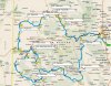
There is a Streets and Trips map attached that details the trip, and there are tags that reference the book above with route numbers and names. I say about on mile because my Streets and Trips miles and the bike bikes do not align. And as mentioned the GPS didn?t work for part of the trip. I will make more posts this week when I get the photos sorted for the good ones. When the GoPro has a full charge you can take a lot of photos in a short time. I have several hundred to go thru.
Day 1
Castle Rock to Frutia the long way, about 423 miles. As usual the goal of our trips is to minimize interstate highways, so we ended up with around a 120 miles of interstate. Everything else ways 2 lane less traveled roads. This was all about roads and not so much about historic and museum rides. Each day was great but there of course are certain roads that stand out. County 27 or (Twentymile) from Oak Creek to Hayden. This is a lovely 23 miles of long low speed swipers that is a top the largest underground coal mine in the US. You would never know. Just as a note we drove all of the two lane roads at posted or under. The scenery was spectacular and you either looked at the scenery or the road. Riding anything over the posted was all about the road. Some of these are unforgiving if a mistake is made.
Then the other great road for Day one was from Rangely to Loma, Highway 139 (Douglas Pass). 70 miles of ever changing topography and great red roads on the Butler maps. Ending up in Frutia and having pub grub at Suds Brothers Brewing. Walking distance to the H Motel, not fancy just cheap and clean.
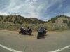
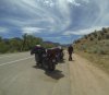
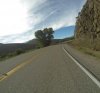
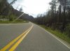
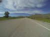
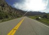
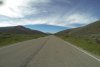
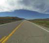
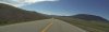
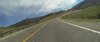
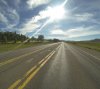
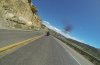
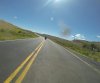
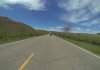
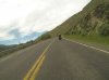
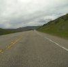
Attached to this post is a shot of the route and some pictures along HWY 13 from Craig to Meeker - Williams Fork Canyon.
So this was the start of it. Now a couple of weeks ago there was a post for a RTE her in Colorado to go to Dillion, Colorado for breakfast. So another question hey do you want to do the RTE on Saturday morning as the start of the Father?s Day weekend. She replied ?Sure.? So, yet again, another map revision.
We have been talking about going to parts of Colorado where we have not been by planes, trains, autos or bikes so we pulled out the trusty book of Colorado motorcycle roads, ?The Complete Guide to Motorcycling in Colorado?. A good book to have around. So our focus was to get from Castle Rock, CO to Dillion, CO and somewhere in northwest, Central West and South West Colorado and back to Castle Rock in 3 days. I am think 1000 to 1200 miles, but I needed to keep in mind that this will be Anita?s first long trip riding her bike (a 2000 ST1100) with really no days for breaks. She is also a novice rider so a focus on the roads is important.
So in the end we had a wonderful time over three days riding the parts of Colorado that we had no idea that existed. We did 1074 miles in three days at a leisurely pace. But, yep there is always a but isn?t there. After breakfast and getting ready to go from the Arapahoe Caf? in Dillion, I plugged in my GPS, it booted and shut off. This happened many, many times and finally somewhere in northwest Colorado it turned on and stayed. Well that night at the motel in Frutia, CO I ended up deleting a bunch of archive data and then it started to work again. So I missed a portion of my route capture. Also My GoPro (the Hero 3 Black) is very disappointing in that it only holds a charge for about 1 ? hours using it only for Stills. So Again there are many portions of the trip that I did not get a lot of pics on. And then Finally on the second day on Grand Mesa Scenic Byway we pulled out in somewhat of a precarious pull out. Anita parked her bike and I went to park mine and it was headed downhill slightly and more straight up then I like it and when I went to get off the bike rolled forward and tipped to the right side and went down flipping me off the bike. Pride was hurt and the bike suffered the infamous broke mirror cover. I maybe should have left it gear this time. A lesson learned or maybe a better parking spot.
So if anyone has a right hand mirror cover for a ST1100 with no cracks send me a PM. I don?t care about color but black is good.
There is a Streets and Trips map attached that details the trip, and there are tags that reference the book above with route numbers and names. I say about on mile because my Streets and Trips miles and the bike bikes do not align. And as mentioned the GPS didn?t work for part of the trip. I will make more posts this week when I get the photos sorted for the good ones. When the GoPro has a full charge you can take a lot of photos in a short time. I have several hundred to go thru.
Day 1
Castle Rock to Frutia the long way, about 423 miles. As usual the goal of our trips is to minimize interstate highways, so we ended up with around a 120 miles of interstate. Everything else ways 2 lane less traveled roads. This was all about roads and not so much about historic and museum rides. Each day was great but there of course are certain roads that stand out. County 27 or (Twentymile) from Oak Creek to Hayden. This is a lovely 23 miles of long low speed swipers that is a top the largest underground coal mine in the US. You would never know. Just as a note we drove all of the two lane roads at posted or under. The scenery was spectacular and you either looked at the scenery or the road. Riding anything over the posted was all about the road. Some of these are unforgiving if a mistake is made.
Then the other great road for Day one was from Rangely to Loma, Highway 139 (Douglas Pass). 70 miles of ever changing topography and great red roads on the Butler maps. Ending up in Frutia and having pub grub at Suds Brothers Brewing. Walking distance to the H Motel, not fancy just cheap and clean.
Attached to this post is a shot of the route and some pictures along HWY 13 from Craig to Meeker - Williams Fork Canyon.
Attachments
-
 148.3 KB Views: 54
 -
 142.1 KB Views: 27
 -
 98.8 KB Views: 19
 -
 118.7 KB Views: 19
 -
 123.3 KB Views: 20
 -
 109.8 KB Views: 31
")