Day 16 ? Saturday September 3rd
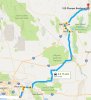
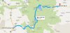
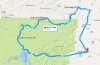
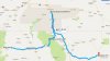
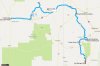
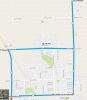
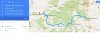
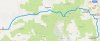
Planned route for the day:
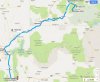
The plan for the day was to ride down to Rainbow Point in Bryce Canyon, ride back out, then head over Hwy12 to Hwy89 south, then Hwy9 through Zion. We would continue to I15 and head south to St George, then go back through Las Veags the way we came so we could stop by and see Hoover Dam and the new bridge and spend the night in Laughlin.
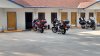
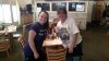
Sometimes things just don?t go as planned! So we got up, got dressed and headed to the Motel Office for their ?Breakfast?. After seeing everyone there, we choose to go eat at the restaurant that we ate at the night before. Besides, they gave 10% if you were in the Motel!
So, Dave and I order the same thing, but instead of a ?meat? omelet, she gave me a vegetable omelet! UCK! So she had to take it back and about 20 minutes later, I get my all meat one! The problem was, that delayed us even more. So now we were a lot later getting away than we wanted.
As we got to the Bryce Canyon gate, a line had already formed. Dave got in one line and I got in the other. As I told Dave as I was a car or two ahead of him, it only takes one to completely screw everything up! I hate it when I?m right! Dave was about 5 minutes ahead of me getting through the gate. I had several vehicles in front of me that caused issues!
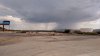
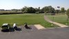
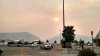
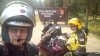
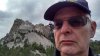
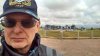
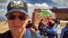
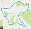
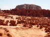
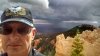
But we got in and headed towards Rainbow point, about 16 miles away. The further south we went, the clouds got darker! But we made it to Rainbow Point and took a few pictures before leaving.
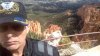
Off in the distance we could see even darker clouds and decide it was time to head back,
although there were a few spots we still wanted to check out.
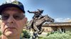
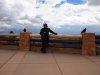
At one spot we stopped, there were a couple of Ravens sitting on two large posts. After Dave and I posed with them, a couple of gals went to pose with them when they started Squawking. Really making some racket! I told the gals they are complaining, they wanted $15 an hour to have pictures with them! LOL
As we were getting close to the entrance, we were getting a few drops on us, so we stopped and put the cameras away. Then we stopped again and put some rain gear on. This made us a little too warm, but kept us dry.
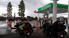
And just as we were getting out of the park, it started coming down pretty hard! I knew that there were a couple of gas stations up ahead, so we picked the first one and ducked under it. After filling the bikes up we decided it would be a good time to take a break, so I told Dave to ride over in front of me, where a pump was out of commission and we could just stay there until the rain stopped. So we took a break and watched the rain and lightning for about fifteen minutes or so.
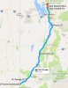
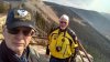
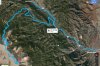
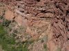
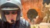
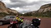
Once the rain was gone, we took off to get back on Hwy12 heading west. We had ridden about 16 miles when we came across Red Canyon and decided we needed to at least take a few pictures!
Just before we rode into Bryce Canyon, we had stopped at a store, hoping to pick up a simi large chip for my onboard cameras. Although they didn?t have any, the guy told me to go to the town of Panguitch, just a few miles north of the US89/UT12 intersection. They had a RadioShack there.
So we headed north on US89. As Dave and I were going through town, we saw a Rexall Drugs, and thought we could stop there if nothing else. We continued for about a mile more and not seeing a RadioShack anywhere, we turned around and headed for the Rexall Drug store we spotted earlier. As we came in view of the Rexall sign, we could see that the RadioShack sign was right below it! DUH!
I went in to pick up a 64GB chip, but saw they had a 128GB, so I got that instead. I went back out and Dave decided to go in and use the restroom, but also decided to get a chip. When he told the guy that he was really disappointed that his brother was just in and bought a 64gb chip, the guy corrected him and said I had bought a 128gb! Dave went ahead and got a 64gb chip. (And later I?m thinking I should have only gotten a 64gb chip, since it seemed that I had issues using the 128 gb chips in my onboard cameras.)
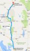
For me to get to my onboard cameras, I had to completely unload my rear saddle! Then remove the saddle to get to the DVR. Once I was all loaded back up, Dave and I took off south on US89. And it was a really good thing we weren?t speeding, there was a cop sitting at the edge of town as we were leaving!
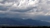
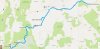
So now we had about 63 miles to the east Zion gate. As we were heading down US89, we spotted a cop, who came in behind us, so I kept to the speed limit and played it safe! Also, as we got closer to Zion, we could see the clouds getting darker and darker!
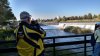
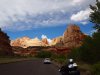
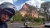
We found 9 and turned on it to Zion and we felt we missed another storm! When I was going through the gate, I asked the Gal if they had gotten any rain yet and she said ?no?, then looked up and said; ?Oh my?, she could see the clouds above us at that time.
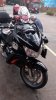
Dave and I pulled in, stopped nearby and set up our GoPros and other cameras and then took off with a few rain drops falling. I?ve gone through Zion a couple of times on my bikes, but only west to east, never east to west. This gave me new views of Zion. Right after we cleared the long tunnel, we came to a pullover area, an ?at an angle" pullover, and I had a heck of a time getting my bike to sit right. But as soon as I shut it down, there goes the ?Camera Stopped? thing again on my on-board cameras!
DANG! Off come my extra bags off the rear saddle and pull the rear saddle up and grab the DVR and pull the battery! Again, I had a 128GB chip in it. I really think it causes it somehow.
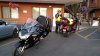
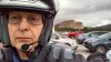
So I got that fixed while Dave was talking to another couple. I loaded the bike back up and after getting a couple of pictures, we were on the road again! As we approached the west entrance, Dave needed a break, so we pulled into the parking lot (what a mess, which is what it is every time I?ve been through!) We found some empty ?20 Minutes Only? spots and pulled into them. Once Dave was in, I pulled my bike next to his space, so others could use the other space I was in.
Again, we were ready to leave. Now trying to get out of that parking lot, pulling a left turn is bad at best! But we did it and then rode out of the park and on our way through Hurricane. But not as fast as we would have liked! Five cages in front of us didn't know what the sign 55 MPH in English meant, so I had to make short work of them! Then, it was slow going for the last mile or two of Hurricane, because they had it down to one lane due to construction, what a mess!
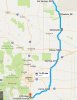
We finally got out of there, and it was like 5pm, but we kept going until we got to I15 to head south. I figured we could gas up in St George, and then ride all the way to Laughlin. It was getting late and by the time we were in Las Vegas, it was dark. So much for Hoover Dam! We were a few miles from a gas stop in Henderson, when my new Sena 20s tells me that my power was low. She said that two more times in a very short distance, and boom, no power! We pulled off, gassed up and then I connected my power cord from my tankbag to my Sena. Working again!
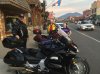
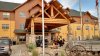
By this time is was just getting darker, so Dave and I just made a be-line to the hotel in Laughlin. Due to a late start, rain delay, traffic delay, we just never could get this day going for us. Oh well, off to the hotel and when we get there, what a mob!
Okay, so the hotel has to upgrade us, well, that didn?t work, since I wanted a non-smoking room! So she tried a few more, nothing! So the kid manager comes over and he gets us in a Handicap room (I don?t like Handicap rooms since an infection I got once a few years ago, but I didn?t have much choice! I then found the bellhop station and got help so we could get our stuff up to our room.
Dave stayed up in the room while I went and wasted a little money in the Casino. Waste of time, I could almost hear the sucking sound in the machines! Oh well, back to the room I went. At lease we were able to sleep pretty well.
Total miles for Day 16 was about: 375

")