Phartz
Pat Thompson
This seemed like the time of year to get over to Arizona and ride that
section of Hwy 191 that I've heard so much about from the AZ gang. You
know, between Alpine and Clifton. So, this morning I took the I-10 out
of the LA area and then after exiting CA headed up the 60, and others, up
to Prescott and headed east from there on 169, 260, 87, etc. over to
Springerville for the night.
It was an awesome lovely riding day the whole way. Clear, sunny,
pleasant temps. Kinda cold in some of the upper elevations. There was a
lot of snow on the ground, particularly up where 260 met up with 87. It
was melting and there was none on the roads. Cold here in Springerville
tonight. Should be about 28F in the morning. Brrr . . .
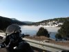
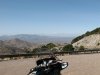
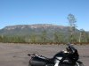
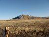
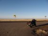
I took a couple of pics once I was down a bit lower with a few remnants
of snow visible. I hadn't been through this part of AZ from Prescott
east. High mountains and pine forests and snow are not what one normally
thinks of AZ. I took one pic where there were still some trees and snow
and another that was far more lunar landscape barren but still quite
high.
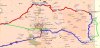
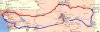
Anyway I'm poised and ready to head down the 191 in the morning and get
on along home. On the map below the red route was the 608 miles for
today and the blue is tomorrow's 750ish miles.

section of Hwy 191 that I've heard so much about from the AZ gang. You
know, between Alpine and Clifton. So, this morning I took the I-10 out
of the LA area and then after exiting CA headed up the 60, and others, up
to Prescott and headed east from there on 169, 260, 87, etc. over to
Springerville for the night.
It was an awesome lovely riding day the whole way. Clear, sunny,
pleasant temps. Kinda cold in some of the upper elevations. There was a
lot of snow on the ground, particularly up where 260 met up with 87. It
was melting and there was none on the roads. Cold here in Springerville
tonight. Should be about 28F in the morning. Brrr . . .
I took a couple of pics once I was down a bit lower with a few remnants
of snow visible. I hadn't been through this part of AZ from Prescott
east. High mountains and pine forests and snow are not what one normally
thinks of AZ. I took one pic where there were still some trees and snow
and another that was far more lunar landscape barren but still quite
high.
Anyway I'm poised and ready to head down the 191 in the morning and get
on along home. On the map below the red route was the 608 miles for
today and the blue is tomorrow's 750ish miles.
Attachments
-
 60.2 KB Views: 81
 -
 77.1 KB Views: 76
 -
 85.6 KB Views: 67
 -
 56.7 KB Views: 67