Google maps and Garmin GPS for motorcycle touring

Joined
Oct 11, 2012
Messages
119
Location
Portland, OR
Bike
Supere Tenere
I don't know how guys crossed the county on motorcycles in the old days, maybe they stopped and asked for directions. Today using Google Maps is a great way to find your way around, especially when paired with a GPS. Here's how I used my Garmin Nuvi to do it.

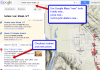
Example: Use the "near" tool with Google Maps. Try these real searches:
hotels near Moab, UT - Pizza near Moab, UT - camping near Moab, UT


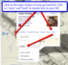
I find the reviews interesting. You can also leave your own reviews. Don't worry about writing down the address though. That's where your GPS comes in. Click on any of the maps markers to bring up an information window. One of the options in the "more" menu is "send." At this point you'll want to connect your GPS to your computer via the USB cable. If you have a Garmin GPS and select GPS, Google will help you download the free Garmin plugin to connect your web browser to your GPS. You may need to restart your browser after installing the plugin but you'll only have to do this once. Once installed, the web browser will be able to see your GPS and send information to it.


In your GPS menu, you will now have the name and location of your target saved as a new favorite. This makes getting there easy using the GPS menus.

Hotel full? Store a second or third option just in case and you can find them too.

Source article: http://st1100oregon.blogspot.com/2012/11/google-maps-and-garmin-gps-for.html
 

Attachments

Last edited:
Joined
Feb 1, 2011
Messages
753
Location
Toccoa, GA
Bike
1200RT, 1200GS
STOC #
8449
Thanks...I just learned something. BTW, can you send an entire route from the desktop/Google Maps to a GPS?
 
OP
OP
pnelson
Joined
Oct 11, 2012
Messages
119
Location
Portland, OR
Bike
Supere Tenere
Good question -- In the past I've used special GPS software to load routes into my Magellan GPS for off-road riding where there are no maps for traditional GPS units. I've not seen a way to do this from Google Maps for an entire route but I bet someone has figured out a way to make it work.

I love my Android smartphone though as all I have to do is open Google Maps and access "My places" and there is my entire route along with hotels, places to eat, all kinds of stuff. You can easily navigate to any of the sites using Navigator. With smartphone navigation being so good, I'm thinking companies that make consumer GPS units are going to be in trouble. Here's my route from Nashville to Portland. http://goo.gl/maps/wrHjh

The one HUGE advantage a traditional GPS has is that it works without a data connection to the Internet. Smartphones need data to work. (Though on my new phone Google Maps has a feature called, make available offline.)

;-)
 
Joined
Feb 17, 2007
Messages
1,131
Location
Sauk Rapids, MN
Bike
05 ST1300
STOC #
6765
I think I am going to enjoy this thread.. I know I will learn something because I already did.. This was very well explained and easy to follow instructions. Thanks..
Yes there is a way to transfer a full route but I dont know how to do this..
 

Bigmak96

R.I.P. - 2021/08/07
Rest In Peace
Joined
Jul 2, 2008
Messages
3,868
Location
Rural Mn
Bike
04 GL1800 Past tense
STOC #
7910
One way that I've found is GMAPtoGPX. It converts a google route to a GPX file, which can than be loaded to your Garmin GPS with Mapsource or Basecamp.

-STeve
I see you are forced to install a download manager with this. Any way around that?
 

drrod

Site Supporter
Joined
Aug 4, 2006
Messages
1,716
Location
Calgary, Alberta
Bike
'04 ST1300
STOC #
8313
You used to be able to send an entire route from Google Maps to the GPS but you can no longer do that. All it will send is the destination point.
If you want to use Google maps to create a route and then send it to your GPS, Then TYRE is a very useful program.
It is free and you can download it here:
http://www.tyretotravel.com/

Rod
 

Raj_Zin

AKA Steve
Joined
Mar 14, 2006
Messages
326
Location
Michigan
Bike
FJR1300A
STOC #
6371
I see you are forced to install a download manager with this. Any way around that?
GMAPtoGPX is a Javascript app - no download required. I think the Download manager box is an ad for... Download manager.

To use GMAPtoGPX, you save the link to the javascript app (that's given in the instructions section) as a favorite, create you directions in google maps, then click on the link you saved as a favorite. A window containing the GPX equivalent opens over your google map. You then need to copy that text, paste it in a text editor and save it as a .GPX file. Seems a bit fidldly...

Having seen gpsvisualizer now, I would use it instead. Seems much better than GMAPtoGPX

-STeve
 

Bones

Your Humble Scribe
Joined
Dec 6, 2004
Messages
4,904
Age
60
Location
western Mass
Bike
2014 BMW R1200RT
STOC #
5575
Great information here, thanks pnelson, et. al.

(I'm up for pizza in Moab, Utah.)
 

ak85lp

(Paul)
Joined
Jul 12, 2009
Messages
331
Location
Franktown Ontario Canada
Bike
2018 VStrom 1000XA
I was not aware of Tyretotravel either but I plan to give it a try. Not sure if anyone knew but to easily find coordinates on Google maps just zoom down as close as you want to the spot (maybe an intersection that has no street address) right click and chose "What's Here". Once you do it will place the Lat and Long in the top search section.
 
Joined
Apr 19, 2012
Messages
390
Location
Moweaqua, Illinois
Bike
2005 Concours
OK, I'll make this simple. Although I'm sure the answers won't be.

For an illiterate like myself...old school map user...what GPS system would be the easiest for me to use. I'd like to get hi-tech, but somehow it is way above my paygrade.

I did just recently get a smart phone. Although I'm not to sure it was a "smart" idea.

Anyway, if at all possible, try to keep it in laymans terms.

Thanks...John
 

Bigmak96

R.I.P. - 2021/08/07
Rest In Peace
Joined
Jul 2, 2008
Messages
3,868
Location
Rural Mn
Bike
04 GL1800 Past tense
STOC #
7910
https://www.youtube.com/watch?v=gPvV_c1M8yc

This guy does a great job of explaining how to use Google Maps and Tyre to make a route. He then looks at it in Basecamp to see how the GPS will interpret the data. That way he shows how to clean out those annoying u turns and loops you didn't know you had till you rode the route.
 
Joined
Dec 13, 2004
Messages
99
Location
Torrance, CA
Bike
2015 Honda VFR ABS
STOC #
1351
This guy does a great job of explaining how to use Google Maps and Tyre to make a route. He then looks at it in Basecamp to see how the GPS will interpret the data. That way he shows how to clean out those annoying u turns and loops you didn't know you had till you rode the route.
I guess this is good if you need to plan your route in Google Maps. But wouldn't the better option just be to create the route in Basecamp and eliminate 2 steps?
 

Kevin_56

Site Supporter
Joined
Sep 3, 2006
Messages
2,826
Age
67
Location
Montfort, Wisconsin
Bike
20 R1250RT
STOC #
6495
But wouldn't the better option just be to create the route in Basecamp and eliminate 2 steps?
This is what some do, but Basecamp can be a little annoying. I use Basecamp for all of my routes. You still need to zoom in on your intermediate points as they do not always get "placed" on the road. I use the move tool and drag the point back on the road. I have had several routes that got Tweeked by my Garmin 650. It makes route changes on its own. Some are good, most are a surprise. I have been routing for many trips using a 550 and NEVER had a route that did not stay on the Basecamp track. The 650 is a different story.

What ever works for you, use it. I just like not having to do any conversions before sending my route to the Garmin.
 
Joined
Mar 6, 2006
Messages
454
Location
WestCentralFla
STOC #
1384
I use my garmin1450 and (gack) the harley ride planner web site. It's a google maps mashup. It has most of the google functions, start loc/end loc and add location. When your route is planned, look in the upper right hand corner and there is a "GPS SYNC" BUTTON. Plug in your gps to the computer, and then hit "detect my device". It loads the route into your gps. With my garmin I have to go into route section and have the gps now create the route with the data sent from the website. It then shows up as a route on my gps. Click on the route and presto..
Another google mashup is Wundermaps.com If you go to the website and click on the weather tab and then Travel and then road trip. Put in your start and end location and the website shows you the weather along your route and at what time that weather will be occuring..
So your gps now has a route and you know the weather along the route, the GPS and google maps will show you where to sleep, eat and get fuel…

What are you waiting for???
 
Top Bottom