Some insight into my "ride around the Great Lakes"?

Stump

Site Supporter
Joined
Jun 29, 2008
Messages
442
Location
Las Vegas, Nv
Bike
VFR1200X
STOC #
7591
I'm planning my '17 ride and want to go around the Great Lakes as a theme. I have planned to hit the south side of the lakes in the Duluth area, heading around the South side of the lakes then up the St Lawrence then up and around the maritime areas of NE Canada and then back on the North side and returning on the Canadian side of the lakes.

Any expertise in the timing of this due to weather or such would be most appreciated!
 
Joined
Jan 13, 2005
Messages
2,565
Location
Muskoka, Canada
Bike
FJR & Super Tenere
STOC #
4759
You could read this. Its an excellent report of a successful Great Lakes Gold ride. A little dated perhaps, but the roads/distances haven't changed in any significant way. Likely most of the gas stops are the same too.

Good luck!

RIP Curt.
 

scootac

Will Ride for Food
Joined
Apr 12, 2006
Messages
2,464
Location
North Central PA
I went around Superior last year. Late August/early September. Temps from 40 to high 80s. Rain and fog for 1/3 of the time. I think any trip around lakes that size the weather can and will change dramatically. Be prepared for cold and wet. Good part is it can change from bad to good just as quick! Depends on how far away from the water you are, and if you are going east-west or west to east.
Regardless of the weather, it's a good ride!
 
Joined
Sep 7, 2006
Messages
31
Age
74
Location
Minocqua, WI
My brother and I ride that southern Lake Superior, Upper Peninsula area a lot. Having been there from early May to mid November, I'd suggest that bugs can be a problem until August. First it's mosquitoes and after that it's the Black Flies. I think the black flies eat the mosquitoes and after that most all of them die or otherwise disappear. Your post didn't say whether you would be camping or not, but the bugs may only be an issue when you're not moving. If you're in the woods they can be maddening until August. Don't want to discourage you. The riding up there is wonderful. What ever you do, don't NOT do this trip.
 

CYYJ

Michael
Joined
Jun 10, 2013
Messages
2,399
Age
69
Location
Toronto & Zürich
Bike
None any more.
STOC #
2636
Hello Robert:

When you plan the northern (Canadian) portion of your trip, be aware that there are only two possible routes around the north of Lake Superior. One is the northern route via Highway 11, through North Bay, Kapuskasing, and on to Nipigon. The other is the more southern route via Highway 17, through Sault Ste Marie, Wawa, Nipigon, and onwards to Thunder Bay. Both of these routes are deemed to be 'The Trans-Canada Highway'. (In theory, there is a third route, via Highway 101 and Chapleau, but don't even think about that route).

Of the two routes, I highly recommend you take the southern route via Highway 17. It is much more scenic, much less lonely, and has more services (fuel, motels, food, towns, camping areas) on it. The northern route via Highway 11 is very sparsely populated and offers very few services. It's also a boring ride - all you will see is rock cuts and trees for 500 miles. Trust me, I grew up in that neighborhood.

I suggest you plan to do the part of your trip that is north of Superior during late June, July or very early August. It starts to get pretty cool at night once the middle of August has passed. Be aware that there are not that many hotels/motels or campgrounds up there (compared to the USA), and there is a lot of touristic traffic on that road in the summertime. This means that you should book ahead if you plan to camp out, or be in a hotel/motel no later than 5:00 PM each night. It's no fun to discover that all the motels in a small town are full at 7:00 PM, and be told that the next motel is only 80 miles down the road, but not to worry, because there is another one 60 miles further on past the first one.

Do not drive at night or at dusk, there are moose and deer everywhere. Besides, the scenery is so nice that you would not want to miss it by driving at night.

In some places, gas stations can be 50 to 70 miles apart, so don't pass an open gas station if your fuel tank is less than half full unless you know 'for sure' that there is a major town within range up ahead.

I don't think you will find a single Honda dealer anywhere in the 1,000 mile long stretch from Ottawa or Toronto all the way to Thunder Bay, so, if you need a new tire, get it in Southern Ontario before you head up north. It would also be a wise idea to print out the Canadian RAN list (available here in the forum) and take it with you, in case you encounter any problems up north.

Just about all merchants (hotel-motels, gas stations, etc.) in Canada use 'chip and PIN' credit card readers - if your US credit card does not have a chip, contact your bank and have them give you a chip card before you leave. There are ATMs at banks everywhere in Canada, and you will get the best rate of exchange by withdrawing Canadian cash from a BANK ATM (not a private ATM) using your US debit card or ATM card. If it says Cirrus or Interac or Maestro on the back of your card, it will work at Canadian ATMs. US cash will be accepted everywhere along the route, but merchants usually offer a very poor rate of exchange.

Canadian speed limits are in km/h. I think that the typical limit on Highway 17 is either 100 km/h (63 MPH) or 90 km/h (about 55 MPH). No cop in the country would ever give you a ticket for doing 10 km/h over the limit (6 MPH over the limit), but once you get above 15 km/h over the limit (10 MPH over), you risk getting a ticket, and there are lots and lots of cops on those highways in the summertime. Your US insurance will be valid in Canada (there is a treaty between Canada and the USA on insurance, if it's good in one country, it's good in the other), but you might have to ask your insurance company to send you a certificate that is suitable for use in Canada. It's sort of a pinkish-looking slip.

Guns are strictly forbidden up here, and not of any use anyway (no-one else has a gun, hence visitors don't need one). Don't even think about bringing a gun into the country, the penalties for possession are very severe.

For budget planning purposes, you can expect that the cost of everything in Southern Canada will be more or less the same as it is in the USA after you account for the currency exchange difference, but up in Northern Canada, everything will be about 15% more expensive than it is in the USA. Fuel is somewhat more expensive than in the USA, but not by a great amount.

Hope this information helps you.

Michael
 
OP
OP
Stump

Stump

Site Supporter
Joined
Jun 29, 2008
Messages
442
Location
Las Vegas, Nv
Bike
VFR1200X
STOC #
7591
All great information! Thank you so much. Being from the desert southwest I hadn't even though of a "late" start.... But after June trip to Jasper and an encounter with early season mosquitoes I gonna plan for an mid July to start trip.
 

kiltman

Site Supporter
Joined
Apr 27, 2013
Messages
3,285
Age
68
Location
Stratford, Ontario Canada
Bike
2002,ST1100ABS
STOC #
8826
There's a Honda dealer in the Sault, one in Espanola, Sudbury, a good dealer in Sturgeon falls. HWY 101 from Thesalon to Chapleau is nice but Chapleau to Wawa is boring and out in the middle of nowhere are speed traps.Radar detectors are also illeagle in most of Canada. There's one small stretch from Sudbury to Whitefish that is 4 lane and 100km/h the rest of it is 90km/h
the town of Blind River really clamps down on speeders so really try and observe the speed limit in that town. It is picturesque riding beside the Mississaugi River in that area. Just North of the Sault to Wawa you get some spectacular views of Lake Surperior, then around Terrace Bay to Nippigon you get to see the Lake. About 60 miles east of Thunder Bay you hug the Lake again. A good scenic lookout is The "Terry Fox" memorial. On the outskirts of Thunder Bay.
Going around Lake Ontario, there are some very nice secondary roads, but if you need to make time well maybe not there's the 401 parking lot. Toronto seems to have rush hour 24/7
Hwy 3 north of Lake Erie is OK mostly farmland and you rarely see the Lake. Heading North east from Windsor takes you along the eastern coast of Lake St. Clair and Lake Huron. It's cottage area up by Grand Bend, nice provincial park called the Pinery. You can continue to follow the coast up to Tobermory and take the Ferry to Manitoulin Island. Nice views and Hwy 6 is a nice road. I really like the stretch from Whitefish Falls to Espanola.
if you opt to take Hwy400 North, Hwy 69 up through Parry Sound and the Muskokas it's pretty much slab and can be extremely busy on weekends as people escape to cottage country.
you may also want to consider ON-SToc near the end of August... just sayin.
 
OP
OP
Stump

Stump

Site Supporter
Joined
Jun 29, 2008
Messages
442
Location
Las Vegas, Nv
Bike
VFR1200X
STOC #
7591
Thanks Kiltman! even more great insight into the area! Luckily I'm on no schedule so doing the posted speed limit is no problem to me.
 

kiltman

Site Supporter
Joined
Apr 27, 2013
Messages
3,285
Age
68
Location
Stratford, Ontario Canada
Bike
2002,ST1100ABS
STOC #
8826
Thanks Kiltman! even more great insight into the area! Luckily I'm on no schedule so doing the posted speed limit is no problem to me.
As mentioned in some earlier posts we tend to have a bit of tolerance. Safety sometimes dictates that you go with the flow which could be up to 12% faster before the powers that be get antsy. You will see signs outlining the fine structure for speeding.
Also remember to slow down when passing emergency vehicles or move into the next lane if safe. Allow 3ft space when passing a cyclist and 6 feet of space when passing a horse and carriage. ( Hwy 17 between Massey and the Sault are a number of Mennonite communities that share the road)
 

ReSTored

Site Supporter
Joined
Nov 6, 2005
Messages
1,479
Location
Mississauga, Ontario
Bike
2019 Tracer GT
STOC #
4463
Let us know your final plans. I've been thinking about a Toronto loop to Sault St Marie and then cutting south to Michigan's UP and home through Port Huron. But I could be persuaded to go to Thunder Bay and then return to TO through the US.
 
OP
OP
Stump

Stump

Site Supporter
Joined
Jun 29, 2008
Messages
442
Location
Las Vegas, Nv
Bike
VFR1200X
STOC #
7591
I'll do that ReSTored. I have'n't even tagged the STocs in the are of the ride with dates yet. I guess its time to sit down and work on the trip map! Oh darn! :D
 

jfheilman

Site Supporter
Joined
Sep 15, 2006
Messages
460
Location
South Carolina
Bike
2007 ST1300A
I have done a similar trip twice, making sure I saw all the lakes but only saw the southern part of Lake Superior. What I was a trying to do was to match the lyrics of Gordon Lightfoot's song. I made sure I saw Whitefish bay as well and Niagara Falls. I can look for the trip files if you would like and send them to you as GPX files. As I remember it one time was early summer and the other time was late summer. No issues with weather either way but that is going on memory.
 

CYYJ

Michael
Joined
Jun 10, 2013
Messages
2,399
Age
69
Location
Toronto & Zürich
Bike
None any more.
STOC #
2636
... But I could be persuaded to go to Thunder Bay and then return to TO through the US.
Not sure if you have ever driven from Toronto to Thunder Bay (in a car), but be aware it is a heck of a long ride. To put it in context, if you leave Toronto headed for Vancouver, you are more than halfway there before you even leave Ontario!

Michael
 

CYYJ

Michael
Joined
Jun 10, 2013
Messages
2,399
Age
69
Location
Toronto & Zürich
Bike
None any more.
STOC #
2636
Stump:

You might want to consider picking up a copy of Michelin's Regional Map 583 ( http://travel.michelin.co.uk/map-583---northeastern-usa-eastern-canada-scale-12-400-000-1214-p.asp ) and using that for route planning purposes. The scale is a bit too large for day-to-day on the road use (except north of the Great Lakes, where there are not many roads). But, it's a great map for planning and for overall perspective. The link I provided is to a UK vendor, but I am sure the same map is available in the USA from American vendors - perhaps even at a "big box" bookstore.

Michael
 
Joined
Jan 13, 2005
Messages
2,565
Location
Muskoka, Canada
Bike
FJR & Super Tenere
STOC #
4759
I have done a similar trip twice, making sure I saw all the lakes but only saw the southern part of Lake Superior.
Oh oh ... better plan a trip back. You missed the best part. The trip from Thunder Bay thru Wawa to Sault St Marie is beautiful.
 
Joined
Mar 21, 2016
Messages
1,137
Location
P.E.I., Canada
Bike
2005 st1300
Heading North east from Windsor takes you along the eastern coast of Lake St. Clair and Lake Huron. It's cottage area up by Grand Bend, nice provincial park called the Pinery. You can continue to follow the coast up to Tobermory and take the Ferry to Manitoulin Island. Nice views and Hwy 6 is a nice road. I really like the stretch from Whitefish Falls to Espanola.
if you opt to take Hwy400 North, Hwy 69 up through Parry Sound and the Muskokas it's pretty much slab and can be extremely busy on weekends as people escape to cottage country.
you may also want to consider ON-SToc near the end of August... just sayin.
I 2nd the recommendation of going up to tobermory and taking the ferry across to Manitoulin Island. Much nicer than going out to the 400/69 and around georgian Bay. You might want to have a look at this if you haven't already https://www.st-owners.com/forums/showthread.php?156132-Free-Passes-to-Canada-s-National-Parks-in-2017. If you go to tobermory there are 2 parks there and if you are out at the east end of Lake Ontario, there is 1000 islands national park also.
 

CYYJ

Michael
Joined
Jun 10, 2013
Messages
2,399
Age
69
Location
Toronto & Zürich
Bike
None any more.
STOC #
2636
I 3rd the recommendation to go via Wiarton, Tobermory, & Manitoulin Island (rather than Highway 69). Highway 69 between Parry Sound & Sudbury is an awfully boring ride - it is truly the land God gave to Cain - and the section west of Sudbury until you get abeam Espanola is not particularly interesting either. But, to be fair to Sudbury, the geology around that town is quite interesting - it's where NASA tested the moon crawling vehicles back in the 1970s.

There are several national parks in the Tobermory area, but not all of them are suitable for camping. If you want to camp at Five Fathoms National Park, bring a snorkel, because the park is entirely underwater. Here's a link that will give you more information about National Parks in that area: http://www.pc.gc.ca/eng/pn-np/on/bruce/index.aspx . There are lots and lots of Provincial Parks along the route to the Bruce Peninsula. In fact, I think there are only about 6 or 7 National Parks in all of Ontario, but close to 100 Provincial Parks. Here's a link to the Provincial Parks website: https://www.ontarioparks.com/en It is possible to make reservations in advance at many of the Provincial Parks.

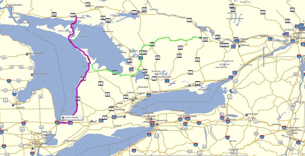
I've made a little map that shows two possible routes via Manitoulin Island. The magenta line would apply to anyone entering Canada from Michigan (cross at Port Huron / Sarnia, not at Detroit / Windsor). The green line would work well for anyone coming from Quebec or the New England states. Highway 60 (the green line) is a more scenic and interesting ride than Highway 7 to the south, and has much less traffic on it than Highway 7. But, having said that, if you are in a hurry and want to 'transit' (rather than 'tour') to get to the Bruce Peninsula and you are coming from the east, take the 401 to Toronto and then Highway 400 north to Barrie. All 400-series roads in Ontario are multi-lane expressways, much like US Interstates, except bigger (Highway 401 is 16 lanes wide across the top of Toronto).

Michael

2 Interesting and Enjoyable Routes to Tobermory (where the ferry is) then onwards to the Trans-Canada Highway
 
Last edited:
Top Bottom