There’s a point in northeastern Arizona where the landscape stops trying to entertain you and simply asks whether you’re comfortable with distance. U.S. Highway 160 is that kind of road.
Running across Arizona’s northeast corner between the New Mexico state line and the Tuba City, U.S. 160 cuts through the vast high desert of the Navajo Nation and the Hopi Reservation. It’s a ride defined by openness – long sightlines, immense skies, and terrain that seems measured less in miles than in geological eras.
For motorcyclists, U.S. 160 isn’t about technical riding. There are no tight switchbacks, dramatic canyon descents, or mountain passes demanding constant input. Instead, it offers something quieter and, in its own way, more demanding: sustained exposure.
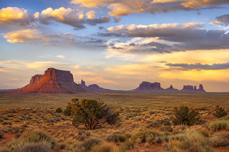
From places like Tuba City, Kayenta, or the eastern approach near Teec Nos Pos, the road unfolds across a broad desert plateau. Long straightaways and gentle curves stretch through landscapes defined by sandstone mesas, volcanic remnants, dry washes, and distant formations that never seem to get appreciably closer.
Storms can be visible an hour before you reach them, drifting across the desert beneath skies so large they distort your sense of distance. Crosswinds move freely across the plateau, sometimes steady enough to become background noise, sometimes strong enough to demand constant bar pressure and attention.
Mile after mile, the road maintains a deliberate consistency. The horizon remains fixed. The sky occupies most of your field of view. Riders settle into a kind of desert cadence where subtle changes – a shift in light, a rising mesa, a distant rain shaft – become the markers that define progress.
U.S. 160 crosses through living Native lands with deep cultural history and contemporary significance. Navajo communities, roadside vendors, trading posts, and small settlements dot the corridor, reminders that these routes existed as places of travel, trade, and habitation long before pavement arrived.
The road also serves as a gateway to some of the Southwest’s most iconic landscapes. Monument Valley lies just north via U.S. 163. Four Corners is a worthy pitstop just off the route, where you can stand in 4 states at once. To the south and west, roads branch toward Hopi mesas, canyon country, and northern Arizona’s broader desert network.
Click here to view the route on REVER
Click here to download the GPS file
Location: Northeastern Arizona
Distance: 169 miles
Ride Time: 1 day
Best Direction: Either direction works well
Skill Level: Beginner to Intermediate (remote travel awareness recommended)
Best Bike Type: Touring, Cruiser
U.S. 160 is generally well-paved and straightforward to ride. The route features long straight sections, sweeping curves, moderate elevation changes, and expansive visibility across high desert terrain.
Surface quality is typically good, though riders should watch for windblown sand, rough patches, expansion joints, and occasional debris. Traffic is generally light to moderate, with activity increasing near communities and junctions.
The primary riding factor is environmental exposure. Strong crosswinds, changing weather, limited shade, and long stretches between services make preparation more important than technical skill.
Spring and fall (roughly March through May and September through October) offer the best balance of temperatures and weather stability.
Summer brings intense sun exposure and afternoon heat across the desert plateau. Late-summer monsoon season can produce sudden thunderstorms, lightning, gusty winds, and localized flooding in washes.
Winter riding is possible but can include cold temperatures, snow, or icy conditions, especially near higher elevations and northern segments approaching Utah.
Carry extra water, monitor fuel carefully, and assume services may be farther apart than they appear on a map.
Food options along U.S. 160 are concentrated around towns and community hubs such as Tuba City, Kayenta, and Teec Nos Pos.
Expect practical traveler fare rather than destination dining: diners, trading post cafés, fry bread, burgers, sandwiches, and roadside staples built for long-distance travelers.
Because spacing between services can be significant, riders shouldn’t count on casual meal stops appearing exactly when hunger does.
Lodging is available in corridor communities including Tuba City, Kayenta, and nearby gateway towns depending on routing. Options range from chain hotels and independent motels to trading-post-style accommodations.
Camping opportunities exist throughout the broader region where permitted, offering classic high-desert nights beneath expansive Southwestern skies.
Advance planning is recommended, particularly during spring and fall travel seasons.
U.S. 160 works exceptionally well as part of a larger Southwest motorcycle loop.
Head north via connecting routes toward Monument Valley and southern Utah canyon country. Ride east toward Four Corners and New Mexico’s desert landscapes. Explore southbound roads leading toward Hopi mesas, Petrified Forest country, or northern Arizona’s higher terrain.
Many riders combine U.S. 160 with U.S. 89, U.S. 191, or U.S. 163 for a multi-day circuit through some of the most expansive riding country in the American Southwest.
The appeal lies in contrast – moving between desert plateau, canyon landscapes, Native cultural regions, and mountain country while experiencing just how large the Southwest can feel from a motorcycle seat.
The post Arizona U.S. 160—High Desert Distance Through Navajo and Hopi Country appeared first on Rider Magazine.
Continue reading...
Running across Arizona’s northeast corner between the New Mexico state line and the Tuba City, U.S. 160 cuts through the vast high desert of the Navajo Nation and the Hopi Reservation. It’s a ride defined by openness – long sightlines, immense skies, and terrain that seems measured less in miles than in geological eras.
For motorcyclists, U.S. 160 isn’t about technical riding. There are no tight switchbacks, dramatic canyon descents, or mountain passes demanding constant input. Instead, it offers something quieter and, in its own way, more demanding: sustained exposure.
From places like Tuba City, Kayenta, or the eastern approach near Teec Nos Pos, the road unfolds across a broad desert plateau. Long straightaways and gentle curves stretch through landscapes defined by sandstone mesas, volcanic remnants, dry washes, and distant formations that never seem to get appreciably closer.
Storms can be visible an hour before you reach them, drifting across the desert beneath skies so large they distort your sense of distance. Crosswinds move freely across the plateau, sometimes steady enough to become background noise, sometimes strong enough to demand constant bar pressure and attention.
Mile after mile, the road maintains a deliberate consistency. The horizon remains fixed. The sky occupies most of your field of view. Riders settle into a kind of desert cadence where subtle changes – a shift in light, a rising mesa, a distant rain shaft – become the markers that define progress.
U.S. 160 crosses through living Native lands with deep cultural history and contemporary significance. Navajo communities, roadside vendors, trading posts, and small settlements dot the corridor, reminders that these routes existed as places of travel, trade, and habitation long before pavement arrived.
The road also serves as a gateway to some of the Southwest’s most iconic landscapes. Monument Valley lies just north via U.S. 163. Four Corners is a worthy pitstop just off the route, where you can stand in 4 states at once. To the south and west, roads branch toward Hopi mesas, canyon country, and northern Arizona’s broader desert network.
Travel Resources
Click here to view the route on REVER
Click here to download the GPS file
At a Glance
Location: Northeastern Arizona
Distance: 169 miles
Ride Time: 1 day
Best Direction: Either direction works well
Skill Level: Beginner to Intermediate (remote travel awareness recommended)
Best Bike Type: Touring, Cruiser
Road Conditions
U.S. 160 is generally well-paved and straightforward to ride. The route features long straight sections, sweeping curves, moderate elevation changes, and expansive visibility across high desert terrain.
Surface quality is typically good, though riders should watch for windblown sand, rough patches, expansion joints, and occasional debris. Traffic is generally light to moderate, with activity increasing near communities and junctions.
The primary riding factor is environmental exposure. Strong crosswinds, changing weather, limited shade, and long stretches between services make preparation more important than technical skill.
Best Time to Travel
Spring and fall (roughly March through May and September through October) offer the best balance of temperatures and weather stability.
Summer brings intense sun exposure and afternoon heat across the desert plateau. Late-summer monsoon season can produce sudden thunderstorms, lightning, gusty winds, and localized flooding in washes.
Winter riding is possible but can include cold temperatures, snow, or icy conditions, especially near higher elevations and northern segments approaching Utah.
Carry extra water, monitor fuel carefully, and assume services may be farther apart than they appear on a map.
Road Food
Food options along U.S. 160 are concentrated around towns and community hubs such as Tuba City, Kayenta, and Teec Nos Pos.
Expect practical traveler fare rather than destination dining: diners, trading post cafés, fry bread, burgers, sandwiches, and roadside staples built for long-distance travelers.
Because spacing between services can be significant, riders shouldn’t count on casual meal stops appearing exactly when hunger does.
Nearby Lodging
Lodging is available in corridor communities including Tuba City, Kayenta, and nearby gateway towns depending on routing. Options range from chain hotels and independent motels to trading-post-style accommodations.
Camping opportunities exist throughout the broader region where permitted, offering classic high-desert nights beneath expansive Southwestern skies.
Advance planning is recommended, particularly during spring and fall travel seasons.
Points of Interest
- Navajo Nation
- Hopi Tribe
- High desert mesas, volcanic formations, and open plateaus
- Monument Valley
- Four Corners
- Trading posts and roadside cultural stops
- Massive sunset views and monsoon storm watching
- Wide-open desert riding with exceptional sightlines
If You Have More Time
U.S. 160 works exceptionally well as part of a larger Southwest motorcycle loop.
Head north via connecting routes toward Monument Valley and southern Utah canyon country. Ride east toward Four Corners and New Mexico’s desert landscapes. Explore southbound roads leading toward Hopi mesas, Petrified Forest country, or northern Arizona’s higher terrain.
Many riders combine U.S. 160 with U.S. 89, U.S. 191, or U.S. 163 for a multi-day circuit through some of the most expansive riding country in the American Southwest.
The appeal lies in contrast – moving between desert plateau, canyon landscapes, Native cultural regions, and mountain country while experiencing just how large the Southwest can feel from a motorcycle seat.
Resources
The post Arizona U.S. 160—High Desert Distance Through Navajo and Hopi Country appeared first on Rider Magazine.
Continue reading...