Customized route planning

Joined
Oct 1, 2018
Messages
100
Age
71
Location
Rebuilding, America
Bike
2022 BMW RT 1250
Hi all,

Not sure if this is the proper place to ask, but I'm trying to plan a multiday backroads route from the north Los Angeles area to the Seqouia's and surrounding areas.
I want to plan the route myself, not have to computer plan it for me with the quickest/shortest route.

If it were just myself on the ride, I could just 'wing it'. However this is a group ride, so some of the others would like/need to know the exact route/milage. I want to be able to print out a map of the route.

Years ago, I was able to plan and print custom routes using a click and drag method. I don't remember which map program I used, but I'm pretty sure it was MapQuest. I do remember it was a free program.

I now have been trying to use both MapQuest and Google Maps. No such luck.
I have entered the start and end locations and the program offers several routes. But I haven't been able to figure out how to click & drag the blue route line to the route I actually want.
When I try to click & drag, the entire map just moves.
I know I can add multiple stops in between the start/stop locations, but that still does not allow for any click & drag routing.
Have the programs changed or is it just me? :rolleyes-2x: Do I need to open an account and log in?

Can anyone suggest a (preferably free) easy, intuitive program that allows simple click & drag routing? Any tips? tricks? links?

Thanks in advance for your help.

Jon
 
Hi Jon,

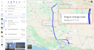
In Google Maps, does your cursor change to a pointing index finger when you point at a route? It worked for me. I was able to modify the route.

1723660111582.png
 
I am just working on this myself as I may be leading a ride in September.

I like google maps, so I'm doing some testing for starting part way through a route etc., to see if it makes you double back, and other unintended features.

If you start the route in Google maps and click along the route you can designate the preferred route. I found that clicking before a corner means you get the prompt to continue and can hit it when stopped or slowed. You use "add destination" to click on the map to send it the way you want to go.

If you revise it later you can just cancel out points to allow you to pick more. Keep in mind the route could shift or "self-optimize" if you take a stop you said you wanted to use. It will automatically pick the "fastest" or "shortest" route depending on what you chose in the settings. It will also show pale blue "other" route options after you email it to yourself and open, make sure you don't tap on the screen and inadvertently pick the wrong one.

Now to learn how to use Garmin...

1723662244710.png
 
add multiple destinations then you can click and drag. If it's too far between destinations that's when itt does it's own thing.
 
On Google maps, you may have to click on the blue "details" to be able to move the route.
 
Try Calimoto and Rever. Both apps have in app purchases you can make to enhance your route planning pleasure but I’ve been able to use their basic functions without laying out additional $ and get pretty decent mapping for routes.

I believe Rever even has an export .gpx function if you would like to import your route into another delivery medium.

Good luck!
 
It is not difficult to plot a route using BaseCamp - Garmin's software. Of course there is a learning curve, but if you are familiar with Windows, you should be able to save a gpx. file in a couple of hours. The major difference between BC and Google Maps, is the former puts you in a specific mode and keeps you there until you click another mode. For example, If you are establishing a via point, every time you click the mouse after setting one point, you will set another. This can be very frustrating if you set a point, then try to grab the map to move it (you have to exit the waypoint mode and click on the move map mode.

@jfheath has posted a link to a website that explains a lot of the features of BC. One major downside (my opine only) is that the Apple and MS versions are similar but not exactly the same, and the tutorials on youtube for apple always seem to not match my computer's BC tools.
 
The only one I've been able to figure out is Scenic. You have to have an iPhone or iPad (for now), and plot your route on that device. I'm not sure if a Mac will work or not. Compared to everything else I used it is easy to plot a custom route with multiple stops. When navigating, it gives you turn by turn directions. I use the phone instead of a Garmin. It can use downloadable maps. For those with Wings, it is in Car Play, so the map shows up in the main screen. I can send my route to others via email, or post the route on a Facebook group so others can download it, either in Scenic or GPX. I really like it.
 
Hi Jon,

In Google Maps, does your cursor change to a pointing index finger when you point at a route? It worked for me. I was able to modify the route.
After opening Google Maps, I finally got the pointy finger after pointing at the Google Map suggested route. I was able to modify the route, but with some mistakes.
...
If you revise it later you can just cancel out points to allow you to pick more. Keep in mind the route could shift or "self-optimize" if you take a stop you said you wanted to use. It will automatically pick the "fastest" or "shortest" route depending on what you chose in the settings...

How do I go about canceling out points? Sometimes after I click & drag to adjust the route, I accidently double back on the route or create a loop in the middle of the route.

What satnav and computer do you have @Team2010 ?

I'm using a cheap Garmin on the bike and using Google Maps on a PC.
 
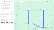
This is the type of stuff I need to delete. The Woodford, Walong, Marcel leg.
1723706198196.png
Hi Jon,

In Google Maps, does your cursor change to a pointing index finger when you point at a route? It worked for me. I was able to modify the route.

1723660111582.png
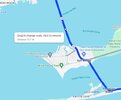
Similar to STRiders post, when I am moving the route if I hold my mouse pointer right over a "dot" on the route mine says "Drag to change route or click to remove". Try hoovering near the dot on the loop below Woodford and see if you can just click near it to remove it.

router.jpg
 
After opening Google Maps, I finally got the pointy finger after pointing at the Google Map suggested route. I was able to modify the route, but with some mistakes.


How do I go about canceling out points? Sometimes after I click & drag to adjust the route, I accidently double back on the route or create a loop in the middle of the route.


I'm using a cheap Garmin on the bike and using Google Maps on a PC.

When using the map and selecting route points I use the "add destination" to make my next selection. As in this example there are only three points and I don't like the last point, so I hover, click, whatever it takes on the point, and the X with a circle around it appears. Click the X and it's gone. The list will now have only two points.


1723722873100.png
 
Last edited:
Next example. Multiple points, and deleting some, mid-string, can change the route.

This is the route I want to take, but I don't want to have to keep pressing the continue button each time I get to a "destination" that I had to chose to make my route work. So, I delete a couple thinking the route will stay the same...And it does not.

1723723362618.png

This is just an example of how it can work, and yes I had to remove several steps for it to happen (poor planning on my part) but a single point could achieve the same mistake.

1723723270655.png
 
One of the best Satnav programs I have used is
You can export your route to most popular satnav programs or naitvely export to a connected TomTom device.
 
I'm using a cheap Garmin on the bike and using Google Maps on a PC.

Ok, a Garmin - but which model is the Garmin ? Before I can give an answer to your original question, I need to know what your Garmin unit can actually do. If I do not know the particular Garmin, I can look up its features and go from there. Presumably it is capable of loading external files such as GPX files.

Some people swear by Google and can make it work for them. But I see so many issues from people who use Google maps. One issue is that it does not create routes. It creates tracks.

Tracks can be converted into routes - but the software that does it is rather clunky - generally sampling the hundreds/thousands of points that make up a track and reducing it to 10-20. I suspect that many people use the facility on some zumos to navigate a track (convert it to a trip or route) - but this facility doesn't exist on all zumos. Even the ones that have it - you have to be very careful with the design of the route.
 
Sorry about that. It's a Garmin Drive 52 EX.
That's a car satnav... usually car units are not capable of loading/handling pre-planned routes... they're pure "address finders", means finding a way to one point, not multiple...
From what I can decipher on the Garmin pages does [roadtrip ready] stand for "commercial targets" (read advertisements where/what to buy) along the way...
 
One of the best Satnav programs I have used is
You can export your route to most popular satnav programs or naitvely export to a connected TomTom device.

I've been using this program for several years. Free, intuative, creates GPX files I load into my Garmin XT.

Does the Garmin you're using have "Trip Planner" in the menu. If so, then you can create routes in Tyre, save to a GPX file, then load into the GPX folder in the Garmin.
 
OK - I've looked at the Drive 52 EX - using on-line videos to get the information that I need - almost anyway.

It is a reasonably modern stanav - showing similarities to the screen layout of the Zumo 595 - so I am guessing that the basic operation is similar. From what I have seen that certainly seems to be the case.

There is no Tracks App - which limits the options.
There is no indication of the type of route that it will accept - so I would need you to carry out an experiment - if you want to take this information further.
The manual (I can only find the Drive 52 Live & Traffic) indicates that you can connect a USB cable to transfer data and download maps - your post suggests that is what you have been doing.
There is no indication that I can find of the type of routes that it will accept.
The Garmin Basecamp Compatability page lists these devices (ie 52 & Live Traffic) - but it doesn't show the Drive 52 EX as being incompatible with Basecamp.
  • Garmin Drive 40LM, Garmin Drive 50LM, Garmin Drive 51 LMT-S, Garmin Drive 52 & Live Traffic, Garmin Drive 60LM, Garmin DriveAssist 50LMT-D, Garmin DriveAssist 51 LMT-S, Garmin DriveLuxe 50LMT-D, Garmin DriveLuxe 51 LMT-D, Garmin DriveLuxe 51 LMT-S, Garmin DriveSmart 51 LMT-S, Garmin DriveSmart 55 & Live Traffic, Garmin DriveSmart 61 LMT-S, Garmin DriveSmart 65 & Live Traffic, Garmin DriveSmart 65 with Amazon Alexa, Garmin DriveSmart 66, Garmin DriveSmart 76, Garmin DriveSmart 86, Garmin
So Basecamp is a very feasible option. Ignore the nay-sayers - it is an excellent route planning tool, it is free and it can load in the maps that are compatible with your device - assuming that your device comes with a licence to update your maps.

In addition Basecamp will generate a track of your route (which I don't think that you can use in your 52 EX) - but which you can use in most mapping software if you want to produce a plot of your routes.

So - here is a route that I plotted on USA maps in Basecamp (I'm in the UK) . There are two version of the same route. One with a combination of Via and Shaping points. One which contains only Via Points. The maps that I used are City Navigator North America NT 2025.1

It would be useful to know what each on looks like in your Trip Planner list and on the preview map. The route goes from near Bakersfield to Pine Flat Reservoir.
In particular when you load each route - a) does it load OK. b) Does it show flags on the route c) does it show small discs on the route.

To update your maps to your Garmin 52 EX - you need Garmin Express. https://www.garmin.com/en-US/software/express/windows/

To download Basecamp - you need to download it from here: https://www.garmin.com/en-GB/software/basecamp/ - use the default location for installation.

Once Basecamp is downloaded and installed (use the default location) you can use Garmin Express to install the same maps onto your computer for Basecamp to pick up.

Most of the online tutorials are heavy going when it comes to Basecamp - it is so sophisticated that it can take some learning how to do everything. But these very quick videos that I created get the point across - no frills no heavy duty stuff. I hope You tube haven't interrupted them with adverts. I've tried to keep them to 3 minutes each.

Video 1 - 2:36 - Set up Basecamp ready for use.
Video 2 - 1:51 - Create a very simple point to point route with the route tool.
Video 3 - 2:15 - Create a Multipoint Route in Basceamp.
Video 4 - 2:50 - Use the Insert Tool to Modify a Route in Basecamp
Video 5 - 2:23 - Create Waypoints
Video 6 - 2:21 - Create a route from saved Waypoints

I am unsure whether or not the Drive 52 EX will process waypoints. Waypoints are special saved location on the garmin. The Zumo calls them Favourites in the UK or 'Saved' in the USA. If you click on 'Where To ?' on the main screen and there is a button for 'Saved' or 'Favourites'. If you have that, then your satnav knows about them - otherwise Videos 5 and 6 are irrelevant for you Garmin 52 EX.
 

Attachments

  • Two Sequoia Routes.gpx
    1.1 MB · Views: 2
Last edited:
Back
Top Bottom