Excellent route planning and turn by turn navigation. Free!

TMF

Joined
Oct 27, 2021
Messages
110
Age
66
Location
Brookeville, MD
Bike
1992 Honda ST1100
For trip navigation, I've been trying GPS products, computer programs and websites on and off for years now and have settled on the system described below. It touches all the bases for me - free, cellphone based, turn by turn navigation voiced in my ear, routes of unlimited length and a navigation app that handles deviation from route quite well and gives early warning of upcoming turns. Maps zoom in automatically as turns come up. Routes can start anywhere which is fantastic because you already know your local roads and don't need to plot 20 turns to get to parts unknown. You'll be guided to the starting point of the route regardless of where you start.

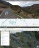
To construct a route go to the free website gpx.studio. Build a route of any length click by click. If you make a mistake right click on the last segment's tiny circle to delete. Save the route as a GPX file to your computer then email it to yourself as an attachment. Open that email on your cellphone and download the GPX file. Now, open the free OsmAnd app (android based; not sure about iPhone), find and load the GPX file. There's a learning curve with OsmAnd but stay with it. Once going, you'll hear turn by turn instructions in your ear and be able to follow truly excellent maps on your phone superior to the paid Rever service I abandoned. The only glitch is that the maps and routing are excellent but the voice in your ear makes mistakes at least in the boonies of W.Va., so give priority to what you see.

Ideally you'll have a USB charger for the cellphone and a mount. A USB headset is best for keeping your eyes on the road and hearing turn by turn directions. I bought mine cheap on EBay. Search "bluetooth headset for motorcycle helmet" or similar. My Senna compatible unit ran $25 and features a microphone, external volume, radio tuning and long battery life. It paired easily and permanently to my phone.
 
Joined
May 3, 2011
Messages
319
Location
Rochester, NY
Bike
2008 ST1300
STOC #
8441
I discovered OsmAnd a few weeks back looking for a phone app so I didn't have to buy Garmin maps for Europe for an upcoming trip.
It is a great app, but the free version limits you to like 7 maps, and it counts each state as one.
I build my route in Google Maps, export the KML, then use one of many free web choices to convert it to a GPX track (currently GPS Visualizer).
No "BasicCamp" involved!
 

Sidekick

Save Ukraine Stop War!
Joined
Apr 25, 2017
Messages
341
Location
Rhinebeck, NY
Bike
ST1300A '05
STOC #
#9085
Thanks for the review of OsmAnd!
The spirit of open source software is certainly very attractive and allows multiple plugins and features.
But OsmAnd does not have any windows option (still 87% of the OS market) and planning day trips on a small phone screen is not very convenient.
Give me OsmAnd on Windows and I would certainly jump on the bandwagon!
 
OP
OP
TMF

TMF

Joined
Oct 27, 2021
Messages
110
Age
66
Location
Brookeville, MD
Bike
1992 Honda ST1100
I discovered OsmAnd a few weeks back looking for a phone app so I didn't have to buy Garmin maps for Europe for an upcoming trip.
It is a great app, but the free version limits you to like 7 maps, and it counts each state as one.
I build my route in Google Maps, export the KML, then use one of many free web choices to convert it to a GPX track (currently GPS Visualizer).
No "BasicCamp" involved!
Correct me if I'm wrong but I recall a limit on the number of turns Google Maps allows and that being a deal breaker.
 

drrod

Site Supporter
Joined
Aug 4, 2006
Messages
1,706
Location
Calgary, Alberta
Bike
'04 ST1300
STOC #
8313
Apparently it is possible to use Osmand on a PC. I have not tried this as I use it on a Chromebook, but here is a link if you like.


Sidekick

Save Ukraine Stop War!
Joined
Apr 25, 2017
Messages
341
Location
Rhinebeck, NY
Bike
ST1300A '05
STOC #
#9085
Apparently it is possible to use Osmand on a PC. I have not tried this as I use it on a Chromebook, but here is a link if you like.

Thanks you!
But this is an Android App not PC.
The only way to use it is to install an Android/PC emulator like BlueStack.
Too slow, buggy and unpractical, I did try it...
 
OP
OP
TMF

TMF

Joined
Oct 27, 2021
Messages
110
Age
66
Location
Brookeville, MD
Bike
1992 Honda ST1100
I don't see the need for Osmand on the PC, not with the superb and free gpx.studio to create routes.
 
Joined
May 3, 2011
Messages
319
Location
Rochester, NY
Bike
2008 ST1300
STOC #
8441
Correct me if I'm wrong but I recall a limit on the number of turns Google Maps allows and that being a deal breaker.
Yes, the number of waypoints is limited (these are destinations you type in), but actual viapoints that you drag the line around with are capped at 24. I rarely find this an issue.
For most of my trips over 300mi per day I have an AM and PM route that uses a stop as the am endpoint/pm start point. Then the line is dragged to wherever you want.
Google maps isn't perfect, a big one would be to assign different colors to each route lol
Its very easy to build a trip, especially because you can have a second route viewing window open so you can have a different map and street view (see attachment)

I usually export the KML directly into BasiCamp for the translation to GPX, but able to skip this step using GPX Visualizer or the like to import into OsmAnd.

Here's an example of a 2000mi epic trip that was built with Google Maps, then exported to Garmin for GPX.
 

Attachments

drrod

Site Supporter
Joined
Aug 4, 2006
Messages
1,706
Location
Calgary, Alberta
Bike
'04 ST1300
STOC #
8313
There are many free navigation and route building programs. There are also many relatively inexpensive ones. Here is a thread on Advrider that contains a lot of information.


sirepair

Let's RIDE!
Site Supporter
Joined
Jun 7, 2007
Messages
3,233
Location
Chillicothe, Ohio
Bike
2003 ST1100P
STOC #
7105
I came across Osmand+ several years ago. Bought a used Kyocera Duro Pro cell phone (waterproof and glove friendly) and run it as a backup for my Garmin. I'll sometimes run them side by side to see how each unit deals with the GPX files. There is a learning curve, but it works well. Imports and exports gpx files, and all the maps can be downloaded to a SD card and moved from device to device. I have the paid version which IIRC was about $10-15. And the Kyocera also serves as a backup phone should my primary die, just have to move the SIM card to it. I also use it as my "mirror" in my truck when pulling my enclosed trailer which I've added a wireless camera to the back of, very helpful.
 

rjs987

Robert
Site Supporter
Joined
Sep 25, 2009
Messages
3,055
Age
68
Location
West Des Moines, IA
Bike
2022 Kymco AK 550
2024 Miles
001361
STOC #
8058
Yes, many different ways to set up GPS navigation and many apps available for it.
Yes, Google Maps has a limit of 10 STOP points. They are not waypoints. In Google Maps the navigation stops when you reach a stop point and you have to actively tap the continue button to continue with navigation. I've been using Google Maps for navigating since 2018 and that was really the only issue I had with it. Auto recalculate and navigation to the start point were great in Google Maps so I could gain one point by starting the route at the "next" stop point. I also set an AM route and PM route due to the limited number of stop points. My gloves have a phone ready finger tip so I could continue my routing from every stop point.

Now I have navigation built into my current ride and regularly updated mapping via my cell phone since all navigation information is pushed to the bike from my phone. But it also has only 8 waypoints so I'm still using an AM and PM route and find I can still make a route with less than 8 waypoints usually. Also voice turn by turn and reminders with zoom-in for turns as I get close. No need to convert any files or upload or download anything since I plot my routes within the app and then the bike shows the route when I turn the bike on.
 
OP
OP
TMF

TMF

Joined
Oct 27, 2021
Messages
110
Age
66
Location
Brookeville, MD
Bike
1992 Honda ST1100
Yes, the number of waypoints is limited (these are destinations you type in), but actual viapoints that you drag the line around with are capped at 24. I rarely find this an issue.
For most of my trips over 300mi per day I have an AM and PM route that uses a stop as the am endpoint/pm start point. Then the line is dragged to wherever you want.
Google maps isn't perfect, a big one would be to assign different colors to each route lol
Its very easy to build a trip, especially because you can have a second route viewing window open so you can have a different map and street view (see attachment)

I usually export the KML directly into BasiCamp for the translation to GPX, but able to skip this step using GPX Visualizer or the like to import into OsmAnd.

Here's an example of a 2000mi epic trip that was built with Google Maps, then exported to Garmin for GPX.
Save a lot of effort and create your gpx files at gpx.studio. No limit on turns and no conversion required.
 
Joined
Mar 27, 2021
Messages
62
Age
67
Location
Lake Orion, MI
Bike
2000 ST1100
Save a lot of effort and create your gpx files at gpx.studio. No limit on turns and no conversion required.
I started playing around with gpx.studio and like the mapping function. When I load a file into Osm I do get the turn by turn announcements but only "turn left, turn right, etc." with distance to the turn but not street names. I think this may be because gpx.studio doesn't include that info in the file and Osm only uses what it is sent. I guess if you create the file in Osm it knows the street names. Is there a setting or something for Osm to figure out the street names from the gpx file? Or if I want names to be included I may need to use another program that includes the names.
 
OP
OP
TMF

TMF

Joined
Oct 27, 2021
Messages
110
Age
66
Location
Brookeville, MD
Bike
1992 Honda ST1100
I started playing around with gpx.studio and like the mapping function. When I load a file into Osm I do get the turn by turn announcements but only "turn left, turn right, etc." with distance to the turn but not street names. I think this may be because gpx.studio doesn't include that info in the file and Osm only uses what it is sent. I guess if you create the file in Osm it knows the street names. Is there a setting or something for Osm to figure out the street names from the gpx file? Or if I want names to be included I may need to use another program that includes the names.
I found it best to keep an eye on the display because of numerous errors with the voice direction. Not sure how to get those street names you want. I like the route creation process with GPX studio. Maybe the map can be loaded into another app and and resaved to get the street names?
 
Joined
Mar 27, 2021
Messages
62
Age
67
Location
Lake Orion, MI
Bike
2000 ST1100
It looks like there is a feature in Osm that will do what I am looking for. After choosing a GPX track and tapping the navigation button, you need to tap the name of the track where it says: "follow track". In the next screen you can choose "Reverse track direction" if needed and right below that, there is an option called "Attach to the roads". It changes navigation from turn right or left to actual streets.
 
  • Like
Reactions: TMF
Joined
May 12, 2022
Messages
1
Age
54
Location
England
OSMand can do what you say, however, the navigation via sound follow a gpx route will make me crazy as it just intercept all the roundabout exit as undefined exit. it is very odd.
 
Joined
Jun 26, 2015
Messages
41
Location
Mt Tabor, NJ
Bike
2017 ST1300PA
I typically go out for a day ride with only a general idea of where I want to go. I like finding new roads "in the wild" so to speak. Still, it's nice to avoid getting caught up in closed neighborhoods. So I'm looking for a good gps screen that will let me see the roads around me as I ride, and especially to let me zoom in and out easily. I assume they can all display pre-set routes but that's not what I need most of the time.

Does anyone have experience with a device that's good for seeing what's around and picking out roads on-the-fly?
 
Joined
Sep 16, 2018
Messages
408
Location
Northern Baltimore suburbs
Bike
ST-1300A '09/'12
2024 Miles
000298
I'm using the free version of calimoto app:

It's found me some roads that I wouldn't have gone down. Also, you can just tell It to do a round-trip specifying the length. So I just set it and it takes me on a circular trip back home.
 
Top Bottom