I have been thinking about this from sometime and was wondering if anyone does this and what software do you use.
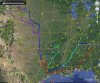
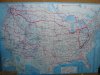
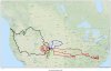
I have a 48" wall map in my living room that I mark up showing all the big trips Anita and I do on the bike. This map is cumulative meaning that I now have three years of routes and all are color coded by year. I laminated tis map and use dry erase markers to show the routes.
I would like to do this with some type of free or inexpensive software that has a street network that I can overlay my routes on and color code them. Tools like Streets and Trips and Google maps are not satisfactory for this.
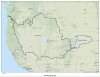
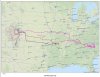
Ideally it would be great if I could import my GPX file and build the routes quickly and then color them as I see fit. Adding a legend would be nice to.
So all of you GIS mapping geeks out there any thoughts?
I have a 48" wall map in my living room that I mark up showing all the big trips Anita and I do on the bike. This map is cumulative meaning that I now have three years of routes and all are color coded by year. I laminated tis map and use dry erase markers to show the routes.
I would like to do this with some type of free or inexpensive software that has a street network that I can overlay my routes on and color code them. Tools like Streets and Trips and Google maps are not satisfactory for this.
Ideally it would be great if I could import my GPX file and build the routes quickly and then color them as I see fit. Adding a legend would be nice to.
So all of you GIS mapping geeks out there any thoughts?