My Big Ride

Saturday June 6

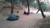
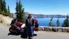
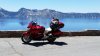
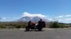
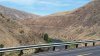
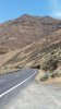
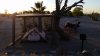
Left Flagstaff and headed south on 89A. Had seen ride reports saying it was a great motorcycle road between Sedona and Prescott. Started off very slow and big time traffic. I thought it was a great road and beautiful scenery but bad timing being a Saturday. Wasn't long before it cleared out and became the all that I had read about. Tight turns, good pavement and great views. I was having so much fun I have no pics of the road. After getting to Prescott I turned my attention to traveling to California. Made it to the KOA in Needles, Ca. before retiring. It was 100 degrees when I arrived. Drove down to the Taco Bell and sat there until the sun started to go down before setting up camp. This is a pic of my camp that I took on Sunday morning. A very nice KOA.
 

Attachments

  • GHoqZR.jpg
    GHoqZR.jpg
    54.8 KB · Views: 45
You mean you put your tent under the cover and not your bike? :eek:4:

LOL

Looks to be a great ride!
 
Sunday June 7

Another traveling day. Hwy 58 off Hwy 40 has some good motorcycling curves. I chose to route north of Los Angeles to stay away from heavier traffic. I know I will end up not doing the full Hwy 1 experience and that's ok with me. I am writing this a few days behind so recommended routes are to late. Sorry. Here is a pic of my campsite at the KOA near Santa Margarita. Would have been my best campsite of the trip except for some late night four wheeling by other campers I presume. Tomorrow Hwy 1!!
 

Attachments

  • 4pWlFt.jpg
    4pWlFt.jpg
    76.2 KB · Views: 44
Great posts so far! looking forward to more pics and info.

Some day I will get to do this type of adventure, love hearing other people getting to enjoy it.

Stay safe.
 
Monday June 8

I load up and make the short run from Santa Margarita and get my first look ever at the pacific ocean. I can see the waves coming and it looks really cool. The air temp is noticeably cold. My dash thermometer says 61 degrees and there is a strong breeze. My first stop is near San Simeon to see the elephant seals. I have only seen them in a zoo or on tv so this is a neat experience. After that I continue up Hwy 1. The road goes high and has tight turns. Should be perfect for viewing the ocean and enjoying leaning the bike over. Unfortunately the fog has rolled in and looking down I see nothing. Traffic was heavy enough that there was always someone slow in front of me. The temps, fog and traffic did not get better all day. I did manage to stop at a beach and get my feet wet.The water seamed about the same temp as the air. I stopped for the night at Costanoa campground. It was close enough to the water that a mist from the fog could be felt. I did take another walk down to the ocean after setting up my tent to experience it some more.
 

Attachments

  • tBxPlb.jpg
    tBxPlb.jpg
    34.2 KB · Views: 18
  • XTrcZ4.jpg
    XTrcZ4.jpg
    20 KB · Views: 16
Tuesday June 9

I travel up Hwy 1 to San Francisco. My tent was wet from the fog/mist when I folded it up. Not enough to be called raining but just enough to keep things wet. I stopped and walked across the Golden Gate bridge. It fascinated me and I was surprised how much vibration can be felt in the handrail from the traffic. Still in the low 60s with fog the traffic cleared out above the city and had a better day. Still it was cold and foggy. Not sure where but after lunch I decided to take a new route close to the giant redwoods that were my next interest. The gps route took me inland and up Hwy 101. The fog cleared and it was much warmer. Got a chance to stop and take some pics of the big redwoods at the end of the day before settling in at Eureka KOA.
 

Attachments

  • qE54JE.jpg
    qE54JE.jpg
    21.5 KB · Views: 23
  • iShwId.jpg
    iShwId.jpg
    96 KB · Views: 26
The Lost Coast south of Eureka is so worth the drive! and make sure you check out the town of Ferndale.. very cool Victorian place!
 
Wednesday the 10th I traveled to Redwood National Park. The volume of large redwoods was well beyond what i had imagined. On the way I stopped by a campground along the way that was loaded with elk. Not sure why they were there but they were not fenced and had no fear of humans. At the park I stopped at Kuchel Visitor Center. They were very helpful and suggested three scenic drives All were worth the time. One was a loop that included a gravel stretch on the bluffs along the ocean. On that stretch was a world war 2 radar station that was disguised as a farm. I found it interesting but seeing I was the only one there makes me question my idea of interesting.
 

Attachments

  • tC0f5m.jpg
    tC0f5m.jpg
    59.8 KB · Views: 30
  • oGOAr9.jpg
    oGOAr9.jpg
    40.6 KB · Views: 30
  • aQHBJu.jpg
    aQHBJu.jpg
    89.1 KB · Views: 31
Thursday the 11th
Rode to Crater Lake National Park. It is one of the most eye appealing places I have seen. The lake created when the top of the mountain blew off is over 1200 ft. deep. It has no water inlets or outlets. 44 ft ave snowfall and rain water keeps it filled. As you can see in the pictures it looks so good it almost looks fake. A lot of time once is enough for visiting some where. I guarantee that i will return to see Crater Lake again.
Friday June 12
Visited Mount Hood. Took every back road I could find. Had a blast on tight curved mountain roads. One suggestion. If you see a road named Mountain View the ST is definitely not the right bike to take on it. Oh it also dead ends. Had to kick some stuff out of my path to turn around. Not my best choice but I am a sucker for roads with mountain or summit in them. Looking for that next great view.
 

Attachments

  • c52lop.jpg
    c52lop.jpg
    74.2 KB · Views: 44
  • YlK4ND.jpg
    YlK4ND.jpg
    62.9 KB · Views: 46
  • 34juxR.jpg
    34juxR.jpg
    68.7 KB · Views: 43
  • LsfWDn.jpg
    LsfWDn.jpg
    104.9 KB · Views: 42
It is Saturday the 13th
Up to date on my post with this one. I start today having already rode 5226 miles on this trip. I guess I can't drive a straight point. Today I go to Mount St. Helens. I didn't do my homework and paid a price today. First I camped in Bay Side thinking I would be going to Seattle this morning but changed my mind and went to St. Helen. Had a lot of back tracking to do. So I punched Mount st. Helens into my smartphone google maps and headed out. It took me to the south side with very few views. If I had researched it i would have known that I drove right past the Ape caves and could have had a great time there. I got stuck turning around near the high point of the road up the mountain. A camper that was entertained with my predicament came and help push me out. Glad he was there, I don't know what I would have done. Then I drove all the way around to the North side and got the great view I was looking for. Had a hard time finding a camping spot today and ended up back in Castle Rock. I bet your starting to understand all the miles. Tomorrow Mount Ranier. Hopefully I have done enough home work to make it a smoother day. Then I plan on finding some twisty roads to take me to Glacier National Park.
 

Attachments

  • SIx2uW.jpg
    SIx2uW.jpg
    51.5 KB · Views: 17
Sunday June 7

Another traveling day. Hwy 58 off Hwy 40 has some good motorcycling curves. I chose to route north of Los Angeles to stay away from heavier traffic. I know I will end up not doing the full Hwy 1 experience and that's ok with me. I am writing this a few days behind so recommended routes are to late. Sorry. Here is a pic of my campsite at the KOA near Santa Margarita. Would have been my best campsite of the trip except for some late night four wheeling by other campers I presume. Tomorrow Hwy 1!!

Nice!.....been to that exact locations a couple times, rally associated with my other listed bike.
 
Great trip, I am loving the pics as I prepare for my trip to Wyoming and Montana.....Thanks for the report
 
The Lost Coast south of Eureka is so worth the drive! and make sure you check out the town of Ferndale.. very cool Victorian place!

It's a fantastic ride down through there. We stayed at the B&B Gingerbread House in Ferndale a few years back. When we rang the door bell in riding gear, the lady politely said 'I'm sorry, you have to have reservations'. We do, she was so embarrassed.
 
Sunday the 14th.
Traveled to Mount Rainier. Got to the correct place this time. On the web site they have correct GPS address to get you to the entrance. Not much of a road report. Went on a hike to Comet Falls. 3.8 mile round trip that kicked my but. When leaving the park I took a road to Packwood that I believe was NF-52 that looked like it would be a nice drive along a river but ended up being terrible because the road was in bad shape. I definitely would not take again. I camped at a state campground off Hwy east of Packwood that was nice.
 

Attachments

  • X8WUEd.jpg
    X8WUEd.jpg
    73.3 KB · Views: 14
  • hvGniz.jpg
    hvGniz.jpg
    54.3 KB · Views: 14
Monday the 15th.
This was a traveling day headed to Glacier National Park. Took Hwy 12 East to Hwy 123 north and then hwy 410 east back to Hwy 12. Great scenic road with great looks at Mount Rainier. Hwy 12 east then takes you to Yakima. Went north on Hwy 97 and turned on to Hwy 821 north. This road runs through the Yakima Canyon and has sweeping turns and great views.Then I worked my way north on Hwy 97 And turned east on Hwy 2 to Spokane for the night at a KOA.
 

Attachments

  • jGHrg8.jpg
    jGHrg8.jpg
    40.2 KB · Views: 8
  • 1OlbSV.jpg
    1OlbSV.jpg
    81.2 KB · Views: 8
  • u10YiO.jpg
    u10YiO.jpg
    48.1 KB · Views: 8
Back
Top Bottom