Curious pattern of GPS location variance

dduelin

Tune my heart to sing Thy grace
Site Supporter
Joined
Feb 11, 2006
Messages
9,685
Location
Jacksonville
Bike
GL1800 R1200RT NC700
2024 Miles
008131
STOC #
6651
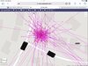
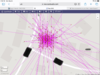
Tonight I was viewing my Spotwalla page that contains all my GPS tracking information for 2023 and saw a curious pattern when I zoomed in on my house. The screenshot below is Spotwalla‘s map portraying my street address zoomed to a scale of 10 meters 30 feet. My house is located on the corner of those two streets. Too many times I have left my SPOT tracker on for hours and the dots on top of and all around my property are reported GPS locations my SPOT sent while it was motionless in the garage. I am aware that there is always some variance in the actual and reported location and the variance is normally within 16 feet. Location scattering is normal but the curious part to me is the heavy clustering of locations in parallel lines running north and south. The lines are 10 to 15 feet apart. First I thought it was because the GPS satellites must be in polar orbits crossing the north and south poles every 12 hours but when I looked this up I found that the satellites have orbits inclined 55 degrees from the equator. Any insights from those better informed than I am?

C42F30D6-21DF-413D-8EE6-1A9B2D8BB573.jpeg
 

amorley

Site Supporter
Joined
Mar 10, 2009
Messages
2,027
Age
69
Location
Houston
Bike
2015 BMW K1600GTS
2024 Miles
001468
SPOT
LINK
Cannot see your image, but my guess is that the GPS accuracy is different N-S vs E-W. The 31 GPS satellites owned by the US that are available for the public to use are all in a geostationary orbit near the equator. My handheld Garmin GPSmap 64st I use for hiking allows me to "see" the 12 or more GPS it is receiving and average all of the signals over a time segment to create a highly accurate waypoint. My guess is that the SPOT GPS does not have such an accurate location.
 

Sadlsor

Site Supporter
Joined
Jan 15, 2020
Messages
4,289
Age
66
Location
Birmingham, Alabama
Bike
2008 ST1300A
STOC #
9065
I know a guy who works for the government, in one of those 3-letter agencies.
He told me the Chinese have been tampering with some of our satellites, and are wiring in an Etch-a-Sketch to each one.
About half of our geostationary sateĺlites have been attacked so far.
 
Joined
Sep 4, 2013
Messages
8,197
Location
Cleveland
Bike
2010 ST1300
How sure are you that the Spot beacon was indeed motionless? Ghosts playing with it? :rofl1:
 

Andrew Shadow

Site Supporter
Joined
Jan 28, 2012
Messages
5,128
Location
Montreal
Bike
2009 ST1300A9
Good question for Michael (@CYYJ). As he used to be a product tester for Garmin and is a pilot, between the two he might have some insight.
 

ST1100Y

Site Supporter
Joined
Dec 4, 2012
Messages
5,039
Age
59
Location
Vienna, AuSTria
Bike
ST1100Y, ST1100R
STOC #
637
IIRC is this called "drift" and a quite common behavior of civilian devices...
 
OP
OP
dduelin

dduelin

Tune my heart to sing Thy grace
Site Supporter
Joined
Feb 11, 2006
Messages
9,685
Location
Jacksonville
Bike
GL1800 R1200RT NC700
2024 Miles
008131
STOC #
6651
IIRC is this called "drift" and a quite common behavior of civilian devices...
I mentioned that in original post. The curious thing is how many locations lined up in parallel rows. Is the image not visible?
 

bdalameda

PaleoCyclist
Joined
Jan 13, 2009
Messages
2,440
Age
67
Location
Salinas, California
Bike
Africa Twin
It seems that GPS location readings can take a little bit of time to stabilize. A few years ago I was searching for a WWII B24 Crash site not far from where I live. I had GPS coordinates to work from and attempted to locate the site. When I was looking for the plane the GPS indicated I was right on the spot but it was nowhere to be found. I was situated right below a large cliff on the ide of a hill. I could not find the plane and talked to some others that had been there before. I realized I was close to it but it was located on the other side of the hill. I did go there again and found the wreckage. The GPS indicated the correct location when I was in the correct location as well as the previous trip where I was in the wrong location. I never have figured out why this happened.
 
Joined
Apr 16, 2010
Messages
1,262
Location
Rochester Mn
Bike
2014 FJR ES 2009 WEE
It's probably tectonic plate shift...slow enough that you don't realize your whole house is moving around....fortunately you won't need ATTGATT or a seatbelt or even an aluminum helmet
 
Joined
Apr 22, 2011
Messages
1,151
Age
68
Location
Camarillo, Ca
Bike
2006 ST1300A
2024 Miles
002552
Long ago, the Gov built in this dither, Selective Availability, to make lower accuracy for commercial users for the sake of "security".
However smart programmers figured out how to get around that by doing lots of averaging.
Since then they have reduced the dither, but it is still there for us common users.
There are better levels of precision for authorized users.....
It can go selectively dark if necessary.
 
OP
OP
dduelin

dduelin

Tune my heart to sing Thy grace
Site Supporter
Joined
Feb 11, 2006
Messages
9,685
Location
Jacksonville
Bike
GL1800 R1200RT NC700
2024 Miles
008131
STOC #
6651
Long ago, the Gov built in this dither, Selective Availability, to make lower accuracy for commercial users for the sake of "security".
However smart programmers figured out how to get around that by doing lots of averaging.
Since then they have reduced the dither, but it is still there for us common users.
There are better levels of precision for authorized users.....
It can go selectively dark if necessary.
Averaging positions over time only goes so far but it was the only game in town in the 80s and early 90s. Rather than smart programmers averaging it was technology innovations and intense lobbying from GPS users like the US Coast Guard and Federal Aviation Administration that negated the dithering from SA even when the Department of Defense was still staunchly opposed to removing it. Differential GPS and WAAS-equipped GPS units reduced induced position errors from SA from tens of meters to the range of centimeters rendering SA actually harmful to users in certain situations like US troops in the Persian Gulf War that were using widely available handheld GPS units. Ironically it was because of SA that technology to defeat it was rapidly developed. Selective Availability was removed by order of President Clinton in 2000. Virtually every moment today a vessel or airplane is using GPS signals for precision location navigation including precision instrument approaches in zero visibility. It can't go dark for them.
 
Joined
Apr 22, 2011
Messages
1,151
Age
68
Location
Camarillo, Ca
Bike
2006 ST1300A
2024 Miles
002552
You are correct. The Dod still controls the system.
It would only go dark if there were a very dangerous event caused by a dangerous world...
But that will never happen...
 
OP
OP
dduelin

dduelin

Tune my heart to sing Thy grace
Site Supporter
Joined
Feb 11, 2006
Messages
9,685
Location
Jacksonville
Bike
GL1800 R1200RT NC700
2024 Miles
008131
STOC #
6651
You are correct. The Dod still controls the system.
It would only go dark if there were a very dangerous event caused by a dangerous world...
But that will never happen...
Our adversaries as well as allies have developed stand alone GPS systems and probably killer satellites. The US Global Positioning System hasn't been the only game in town for over 30 years. It's been possible for a long time to jam GPS signals in specific areas from airborne and ground based equipment. Rather than burning down the house a dangerous event in a dangerous world would have multiple levels of response to choose from.
 

jfheath

John Heath
Site Supporter
Joined
Mar 18, 2006
Messages
2,832
Age
70
Location
Ilkley, W Yorkshire, UK
Bike
2013 ST1300 A9
2024 Miles
000679
STOC #
2570
Curious pattern - the roughly N-S ones are spaced evenly across - suggesting a rounding off of the value for longitude - ie there isn't a value in between the lines. The latitude does it a bit, but the gap isn't as great. I was going to say that longitude lines are closer together than latittude. Which they are - generally. But in Florida ? I wouldn't have thought the difference was that much. If we compared the angle of the vertical patterns of dots with the angle indicated by the compass, we could work out which room you keep your satnav in.

Just think if the early mariners had that information they would never have had trouble getting their longitude.
But if they'd had that info, they could have just used the satnav.

Pretty though isn't it ?
 
Joined
Dec 6, 2018
Messages
1,074
Age
41
Location
UK
Bike
2002 ST1300A
STOC #
9004
Not uncommon at all, though this might be an outlier in terms of it being a little excessive.
IIRC is this called "drift" and a quite common behavior of civilian devices...
This. But also, civilian GPS has a generally accepted accuracy (outside of cities) of +/-10m. Inside cities with high rise buildings, you can get some places that are sheer blackouts for GPS.

I know a guy who works for the government, in one of those 3-letter agencies.
He told me the Chinese have been tampering with some of our satellites, and are wiring in an Etch-a-Sketch to each one.
About half of our geostationary sateĺlites have been attacked so far.
Also this, but again, not so uncommon. Though their recent efforts are actually fairly impressive. I wouldn't bother if I were them... I'd just stand next to you and play havoc with your satnav. Much more fun to see it in person yourself. I guess US immigration prevents most Chinese folks doing that.

Additionally, solar flares make life interesting if you happen to be a geo-stat satellite. Generally, commercial software will adjust, and so long as you can see enough sky, you'll easily stay within +/-3m most of the time. Only thing that usually impacts the software is usually solar activity knocking a satellite or 3 offline.

Source: Stuff, things, work. Not a 3 letter company, but also not civilian.
 

ST1100Y

Site Supporter
Joined
Dec 4, 2012
Messages
5,039
Age
59
Location
Vienna, AuSTria
Bike
ST1100Y, ST1100R
STOC #
637
But also, civilian GPS has a generally accepted accuracy (outside of cities) of +/-10m. Inside cities with high rise buildings, you can get some places that are sheer blackouts for GPS.
IIRC is there a mandatory inaccuracy in civilian units...
Reflections (i.e. building fronts) vary due the changing angles when the sats passing over in orbit...
Weak signals and blockages can occur due tram overhead lines, dense overcast and wet foliage...
The units compensate a lot, but I can often observe the position cursor (as well as the recorded track) running beside the road for a couple of kilometers...
And near sensitive installations, embassies, ministry buildings, etc... reception can be blocked totally... (nice when your hotel is right beside there ;) )
 
Top Bottom