Google Maps Extended Routes

it was a Canadian version, so the Speed Limit signs are the circle and not rectangular!
Speed limit signs are rectangular in Canada, not round. On all the software that I use, including my Garmin GPS, they are rectangular even though the units of measure are set to metric so I doubt that it is a Canadian version. If it is they screwed up.
 
Speed limit signs are rectangular in Canada, not round. On all the software that I use, including my Garmin GPS, they are rectangular even though the units of measure are set to metric so I doubt that it is a Canadian version. If it is they screwed up.

Well, that's interesting, because the ones I see are round on the GPS, and when I look at the "Information", it says "Canada" So, I don't know... Canadian with European signs?
 
Move to Canada?


Steps to Change Units on the zūmo XT2
    • Tap Settings from the main menu or app drawer on your device.
    • Select System.
    • Select Units or Format (depending on the exact firmware version), then choose Measurement Units.
    • Switch the setting from Metric to Statute or change the individual distance/speed metric to Miles / MPH.
    • Sync your device with your phone’s Tread app afterward if route previews on the app still display in metric units.

It's set to Miles.

"Industry Canada Compliance"

It's even in French!

I'll have to try that "Tread App" tomorrow. My Cell phone is already in bed! ;)
 
Well, that's interesting, because the ones I see are round on the GPS, and when I look at the "Information", it says "Canada" So, I don't know... Canadian with European signs?
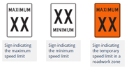
Below is an example of typical speed limit signs in Canada. The wording can change. A sign may state SPEED LIMIT in place of MAXIMUM as an example. Or it may state the unit of measure so that people know whether it is indicating KM/H or MPH, but the shape, the colours, and the writing on it are always the same. I have never seen any other design speed sign in Canada or the US. Most of the content of the highway codes in both Canada and the US were standardized decades ago. I didn't check but I would assume that this is an example of one of the things that was standardized as I don't remember ever seeing any other design speed sign any where in Canada or the US.

If it can't be changed in a setting somewhere, regardless of what it might say on the GPS, I can only assume that there is a screw up somewhere and that this is a GPS that was not intended for the North American market. I would send it back and ask for a replacement on that basis.

1787670689964.png
 
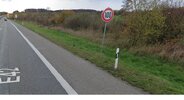
That is a typical European speed limit sign. I restate my position- they screwed up. I'd return it for a replacement designed for North America.
 
Not related to Supe's GPS issue as a CA native I've only seen a MINIMUM speed sign once in my entire life. It was on OK. It was maybe 25-30yrs ago. The sign said MINIMUM with 40 below it.

It struck me as funny since few Californians have to be told to keep up a minimum speed where possible. Obviously it's seldom possible on routes like "the 405" etc.
 
So... back to topic...

I tinkered with that Google Maps Extended Routes extension in FireFox and came up with mixed results...

Yes, it adds the "via points"...
No, it doesn't export a working *.gpx route; opening the file on MapSource (or BaseCamp) just shows 'straight-line routing' from A to B to C to etc...
Not enough for the dense webs of the European road layouts, where C could be reached from B via 5 different roads, 4 of which you'd like to desperately avoid for whatever reasons...
So you have to export a track; opening this in MapSource or BaseCamp now shows the actual just created Google Maps route layout...
In BaseCamp I now could convert this into a route (containing 4~5000 track-points such can take a while), which of course lacks any of the previously created via points; just [start] and [end]...
One unintended [recalculate] and your original plan avoiding traffic and roadworks is down the drain...
So better use your plotting tool/cursor in MapSource (BaseCamp) and create a new route on top of that shown track, avoiding the bloody logarithms, creating your route as you had intended...
This you can then high-lite and send to your satnav...

As many of the oh-so-modern new Garmin units are notorious of running amok with unauthorized secret recalculations while down the road, some users transfer the track and the route onto their skittish devices, to display both while on the move for having visual confirmation of still being on the intended roadways, or if that little Android based devil has again silently dragged them elsewhere...
My 22 year old Garmin Quest-I is too plain for such whims...
As long as I not purposely command it to [recalculate] it'll follow a transferred *.gdb route to the last dot... even with no via points set to force the routing over a particular road to circumvent any obstacles...
ze GF's Zumo 220 again tends to be a tad moody, it already has that [importing route...] feature(?! :cautious: ), during which it definitely recalculates anything transferred from the PC, stubbornly following its internally set routing logarithms... so without sufficient numbers of set via points the thing drives anywhere but the original route...
My conclusio:
Google Maps Extended Routes seems good for checking actual traffic situation across Europe and exporting a track avoiding hold-ups as blueprint for your route... nothing beyond that...

 
Last edited:
Back
Top Bottom