
CYYJ
Michael
Hello All:
I ordered a TomTom Rider 550 GPS this week, to use on my upcoming trip to Tunisia. When I was researching the Rider 550, I couldn't find as much information about it as I wanted to, so what I will try to do in this post is give you more information about the device, and provide an initial comparison to the Garmin 59x GPS device.
I own two Garmins, a 590 (Americas) that I use in North America, and a 660 (Atlantic) that I use in Europe & Africa. I've always used Garmin devices - since 2001, I've owned at least a dozen different ones, from the Streetpilot III through the 296, 396, 496, the Streetpilot 25xx, 26xx, 27xx, and 3 different Zumo series. Up until recently, I've been pretty happy with Garmin products and would not have considered switching brands.
What prompted me to buy the TomTom is that Garmin charges $120 USD for a one-time (non-updatable) purchase of cartography for Tunisia, and their coverage of Tunisia is pretty thin. I've already paid $120 USD in the past for one-time coverage of Morocco, where I rode last year. Those maps are serial-number locked to my aging Zumo 660, which means that if I need to replace that 8 year old device in the future, I'll have to buy the same maps all over again.
By comparison, TomTom provides worldwide coverage - all continents - to owners of the Rider 550, and provides continuous updates of that worldwide coverage at no additional charge. I realize that Open Street Maps (OSM) are available for Garmin devices, but I have not had good experience in the past using crowdsourced OSM cartography. Too few road attributes, and too many routing errors.
Issues Affecting Motorcycle GPS Development
Before getting into a close look at the new TomTom, it's worthwhile to consider what's happening in the world of automotive GPS development. All the portable GPS unit manufacturers have seen a significant drop-off in unit sales in the past 10 years, this because more and more automobiles are equipped with factory navigation systems, and most smartphones can function as automotive GPS navigators. As a result, the portable GPS unit manufacturers have focused their efforts on making inexpensive portable devices that they can sell in volume in lesser-developed countries.
This doesn't bode well for development of better motorcycle navigation systems, because the motorcycle GPS market is very small and motorcycle device development rides the coattails of automotive device development. Garmin has only released a couple of new motorcycle GPS devices in the past 6 years, and the motorcycle GPS market has now stratified into one very high-end (and very expensive) device, the BMW Navigator VI (built by Garmin for BMW), a rather tired and long in the tooth Garmin 595 that is an update of the 6 year old 590, and TomTom's latest product, the Rider 550, which sells at a significantly lower price point than the Garmin devices. I think it is unlikely that we will see a new high-end device released by Garmin in the future. I believe they have ceded that market to BMW and their Navigator VI.
Rider 550 vs Zumo 59x - Initial Impressions
My Rider 550 device arrived today. It wasn't very expensive, about $460 CDN (about $350 USD). This compares favourably to the Zumo 595, which is about half again as expensive.
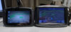
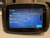
Physically, the two devices are about the same size. If you look at the two devices when they are powered off, screen on the Garmin appears only fractionally taller & wider - about 1/8 of an inch taller, and about 1/4 of an inch wider. The big difference between the two appears once you power the devices up... Garmin's screen resolution is 800 by 480 pixels, vs. 480 by 272 pixels for the TomTom, and Garmin uses the full dimensions of the screen to display the map, vs. a very thick black rectangle around the map on the TomTom device. It's pretty clear that the Garmin device has a bigger screen, but, subjectively, the difference in clarity and resolution between the devices is less than what I would expect when comparing an 800 by 480 device to a 480 by 272 device. TomTom appear to have done a very good job of optimizing the way the map is presented on the screen.
Display Comparison
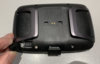
Both devices have a micro-USB port for battery charging and/or data transfer. Both have a slot that accepts a micro-SD card to expand memory capacity. Both appear to be equally waterproof, based on specifications and on the look and feel of the devices.
USB & SD Connections
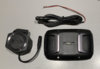
The TomTom device is thinner than the Garmin, which will make it easy to remove it from the motorcycle and stuff it in your pocket when you park the bike. The TomTom attachment device appears to be quite robust and well-designed, allowing one-handed removal and installation of the GPS unit. The back of the TomTom attachment device has a four-bolt fastener pattern that exactly matches the dimensions of a Ram-Mount mounting plate, which means that it will be a 5 minute job to change from an existing Garmin installation on a motorcycle to installation of a new TomTom.
Motorcycle Mount & Power Cable
Setting up the TomTom 550
Switching from a Garmin to a TomTom is a bit like switching from Android to Apple, or from Windows to Mac - it's not just the device that changes, the whole ecosystem associated with the device changes as well.
Garmin owners use Garmin Express to update maps, and either MapSource or BaseCamp (both free Garmin applications) to handle waypoints, routes, and tracks showing travel history. You use a cable to transfer information from your computer to the Garmin device & vice-versa. When you get a TomTom, you set up a 'MyDrive' account with TomTom via the internet, then 'sign in' to your account directly on the Rider 550. The Rider 550 supports direct Wi-Fi connections, and once you have signed into your account on the GPS device itself, it automatically downloads operating software updates and map updates via Wi-Fi whenever it is plugged into external power (either installed on the motorcycle, or connected to 5 volt power via the micro-USB cable). I had no problem setting up the MyDrive account, and once I logged in to my account on the Rider 550 (which also automatically registered the device to my name), the device downloaded a whole whack of updates.
Logging into Wi-Fi
TomTom's behind-the-scenes programming is pretty clever. When I connected the device to Wi-Fi, it figured out that I was in Canada, so it automatically downloaded and updated all the maps for Canada, the USA, and Mexico.
Once you have a 'MyDrive' account, you can manipulate routes & waypoints either on your computer (by logging into the TomTom MyDrive website), or you can download a MyDrive app for either an Apple or an Android phone and manipulate routes & waypoints on the phone app. I haven't done any of this work yet - I'll report on it in a few weeks, once I get familiar with how the app works and become competent using it.
What's in the Box
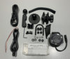
TomTom packages the 550 in two ways: a 'basic' kit, which I purchased, and a 'Premium Pack', which contains everything in the basic kit as well as a mounting system for use in automobiles, a 12 volt cigarette lighter power plug, and a small clamshell case for the device. Unless you plan to use the device in your car, I think it is pointless to get the Premium Pack.
When I was first reseaching the Rider 550, I saw it advertised as a 5 inch device on many sites, and as a 4.3 inch device on other sites. This caused me a bit of confusion - I thought at first that it was available in two different sizes. What I eventually found out, after ordering the "5 inch device" from Amazon, is that it only comes in one size, which has a screen that measures 5 inches diagonally from corner to corner (when the screen is powered off), but only shows an image that is 4.3 inches diagonally when it is powered up.
The pictures below show what comes in the box with the basic device. It pretty much comes with everything one would ever need. I will eventually buy a second motorcycle mount, but only because I have two STs (one in Europe, one in North America).
Hardware that comes with the Basic Kit
I have not yet spent much time using the device - during the next week or so, I'll try to load some routes and waypoints into it, and I'll also use it in my car a bit to see how it performs. It appears that real-time traffic updates and a speed camera database are included free for the life of the product. I'm not sure what kind of weather information is available.
Anyway - this post is just an 'initial impression' and description post. I'll provide more information later, once I have gained some experience with the device and its ecosystem.
Michael
I ordered a TomTom Rider 550 GPS this week, to use on my upcoming trip to Tunisia. When I was researching the Rider 550, I couldn't find as much information about it as I wanted to, so what I will try to do in this post is give you more information about the device, and provide an initial comparison to the Garmin 59x GPS device.
I own two Garmins, a 590 (Americas) that I use in North America, and a 660 (Atlantic) that I use in Europe & Africa. I've always used Garmin devices - since 2001, I've owned at least a dozen different ones, from the Streetpilot III through the 296, 396, 496, the Streetpilot 25xx, 26xx, 27xx, and 3 different Zumo series. Up until recently, I've been pretty happy with Garmin products and would not have considered switching brands.
What prompted me to buy the TomTom is that Garmin charges $120 USD for a one-time (non-updatable) purchase of cartography for Tunisia, and their coverage of Tunisia is pretty thin. I've already paid $120 USD in the past for one-time coverage of Morocco, where I rode last year. Those maps are serial-number locked to my aging Zumo 660, which means that if I need to replace that 8 year old device in the future, I'll have to buy the same maps all over again.
By comparison, TomTom provides worldwide coverage - all continents - to owners of the Rider 550, and provides continuous updates of that worldwide coverage at no additional charge. I realize that Open Street Maps (OSM) are available for Garmin devices, but I have not had good experience in the past using crowdsourced OSM cartography. Too few road attributes, and too many routing errors.
Issues Affecting Motorcycle GPS Development
Before getting into a close look at the new TomTom, it's worthwhile to consider what's happening in the world of automotive GPS development. All the portable GPS unit manufacturers have seen a significant drop-off in unit sales in the past 10 years, this because more and more automobiles are equipped with factory navigation systems, and most smartphones can function as automotive GPS navigators. As a result, the portable GPS unit manufacturers have focused their efforts on making inexpensive portable devices that they can sell in volume in lesser-developed countries.
This doesn't bode well for development of better motorcycle navigation systems, because the motorcycle GPS market is very small and motorcycle device development rides the coattails of automotive device development. Garmin has only released a couple of new motorcycle GPS devices in the past 6 years, and the motorcycle GPS market has now stratified into one very high-end (and very expensive) device, the BMW Navigator VI (built by Garmin for BMW), a rather tired and long in the tooth Garmin 595 that is an update of the 6 year old 590, and TomTom's latest product, the Rider 550, which sells at a significantly lower price point than the Garmin devices. I think it is unlikely that we will see a new high-end device released by Garmin in the future. I believe they have ceded that market to BMW and their Navigator VI.
Rider 550 vs Zumo 59x - Initial Impressions
My Rider 550 device arrived today. It wasn't very expensive, about $460 CDN (about $350 USD). This compares favourably to the Zumo 595, which is about half again as expensive.
Physically, the two devices are about the same size. If you look at the two devices when they are powered off, screen on the Garmin appears only fractionally taller & wider - about 1/8 of an inch taller, and about 1/4 of an inch wider. The big difference between the two appears once you power the devices up... Garmin's screen resolution is 800 by 480 pixels, vs. 480 by 272 pixels for the TomTom, and Garmin uses the full dimensions of the screen to display the map, vs. a very thick black rectangle around the map on the TomTom device. It's pretty clear that the Garmin device has a bigger screen, but, subjectively, the difference in clarity and resolution between the devices is less than what I would expect when comparing an 800 by 480 device to a 480 by 272 device. TomTom appear to have done a very good job of optimizing the way the map is presented on the screen.
Display Comparison
Both devices have a micro-USB port for battery charging and/or data transfer. Both have a slot that accepts a micro-SD card to expand memory capacity. Both appear to be equally waterproof, based on specifications and on the look and feel of the devices.
USB & SD Connections
The TomTom device is thinner than the Garmin, which will make it easy to remove it from the motorcycle and stuff it in your pocket when you park the bike. The TomTom attachment device appears to be quite robust and well-designed, allowing one-handed removal and installation of the GPS unit. The back of the TomTom attachment device has a four-bolt fastener pattern that exactly matches the dimensions of a Ram-Mount mounting plate, which means that it will be a 5 minute job to change from an existing Garmin installation on a motorcycle to installation of a new TomTom.
Motorcycle Mount & Power Cable
Setting up the TomTom 550
Switching from a Garmin to a TomTom is a bit like switching from Android to Apple, or from Windows to Mac - it's not just the device that changes, the whole ecosystem associated with the device changes as well.
Garmin owners use Garmin Express to update maps, and either MapSource or BaseCamp (both free Garmin applications) to handle waypoints, routes, and tracks showing travel history. You use a cable to transfer information from your computer to the Garmin device & vice-versa. When you get a TomTom, you set up a 'MyDrive' account with TomTom via the internet, then 'sign in' to your account directly on the Rider 550. The Rider 550 supports direct Wi-Fi connections, and once you have signed into your account on the GPS device itself, it automatically downloads operating software updates and map updates via Wi-Fi whenever it is plugged into external power (either installed on the motorcycle, or connected to 5 volt power via the micro-USB cable). I had no problem setting up the MyDrive account, and once I logged in to my account on the Rider 550 (which also automatically registered the device to my name), the device downloaded a whole whack of updates.
Logging into Wi-Fi
TomTom's behind-the-scenes programming is pretty clever. When I connected the device to Wi-Fi, it figured out that I was in Canada, so it automatically downloaded and updated all the maps for Canada, the USA, and Mexico.
Once you have a 'MyDrive' account, you can manipulate routes & waypoints either on your computer (by logging into the TomTom MyDrive website), or you can download a MyDrive app for either an Apple or an Android phone and manipulate routes & waypoints on the phone app. I haven't done any of this work yet - I'll report on it in a few weeks, once I get familiar with how the app works and become competent using it.
What's in the Box
TomTom packages the 550 in two ways: a 'basic' kit, which I purchased, and a 'Premium Pack', which contains everything in the basic kit as well as a mounting system for use in automobiles, a 12 volt cigarette lighter power plug, and a small clamshell case for the device. Unless you plan to use the device in your car, I think it is pointless to get the Premium Pack.
When I was first reseaching the Rider 550, I saw it advertised as a 5 inch device on many sites, and as a 4.3 inch device on other sites. This caused me a bit of confusion - I thought at first that it was available in two different sizes. What I eventually found out, after ordering the "5 inch device" from Amazon, is that it only comes in one size, which has a screen that measures 5 inches diagonally from corner to corner (when the screen is powered off), but only shows an image that is 4.3 inches diagonally when it is powered up.
The pictures below show what comes in the box with the basic device. It pretty much comes with everything one would ever need. I will eventually buy a second motorcycle mount, but only because I have two STs (one in Europe, one in North America).
Hardware that comes with the Basic Kit
I have not yet spent much time using the device - during the next week or so, I'll try to load some routes and waypoints into it, and I'll also use it in my car a bit to see how it performs. It appears that real-time traffic updates and a speed camera database are included free for the life of the product. I'm not sure what kind of weather information is available.
Anyway - this post is just an 'initial impression' and description post. I'll provide more information later, once I have gained some experience with the device and its ecosystem.
Michael
Last edited:
 .
.  .
.") I was going to name it "Your kids are noisy", but I figured that wouldn't be best for neighborly relations.
I was going to name it "Your kids are noisy", but I figured that wouldn't be best for neighborly relations. )
)