Flying Your Route in 3D in Google Earth Pro

jfheath

John Heath
Site Supporter
Joined
Mar 18, 2006
Messages
2,847
Age
70
Location
Ilkley, W Yorkshire, UK
Bike
2013 ST1300 A9
2024 Miles
000679
STOC #
2570
I used this trick years ago and I remember that it used a lot of messing about with various apps to get the correct format files.
I revisited it about 2 years ago and for whatever reason it seems to have become much, much easier.

It works with routes using kml files direct from Basecamp and will work equally well with tracks and active logs from a Zumo converted to kml via Basecamp.
Other ways of creating kml files would also work - but since all of my routes and tracks are already in Basecamp ......

Google Earth ScreenShot.jpg

These notes were put together using Basecamp and Google Earth Pro.
 

Attachments

Last edited:
Joined
Jul 24, 2011
Messages
1,027
Age
71
Location
Hereford, AZ
Bike
2020 Moto guzzi V85T
Okay I don't know why I didn't think of this before. I bring a lot of KLM from Basecamp into Google maps but just kind of for got about Google Earth. Just tried this and it works great.

Thanks for the tip. This will make my wife happy when I do dirt road routes.
 

ibike2havefun

Still above the sod
Site Supporter
Joined
Jan 8, 2015
Messages
2,751
Location
Rockville, MD, USA
Bike
Bikeless (9/29/2019)
STOC #
8824
When the earth was still new (or at least when Google Earth was still very new) I hand-wrote a KML file that contained all of the spots where I had taken gravity measurements as part of my Master's degree research back in the mid-1980's. It was fun to load it into GE and hit the Play button, to watch the Indus River snake its way through the Hindu Kush and Karakorum, then leap over a huge pass and down into the Swat River valley.
 
Joined
Jul 24, 2011
Messages
1,027
Age
71
Location
Hereford, AZ
Bike
2020 Moto guzzi V85T
How do you tell Google to 'stick to the roads' on a fly over instead of doing straight lines point to point?
Or did I just miss that in your instructions?

I believe they are different data sets with no relationship to one another other than an approximate geographic location. Your GPS or Basecamp uses different land data to create a route than what google maps or Google Earth uses. So when you import or open a KLM file it is just an overlay in the Google product.

In Google Earth you will also notice a difference in elevation data the imported data will not lay directly on the Google Earth data. Again different base data.
 

Uncle Phil

Site Supporter
Joined
Feb 26, 2007
Messages
11,350
Age
71
Location
In The Holler West Of Nashville, Tennessee
Bike
4 ST1100(s)
2024 Miles
006717
STOC #
698
I believe they are different data sets with no relationship to one another other than an approximate geographic location. Your GPS or Basecamp uses different land data to create a route than what google maps or Google Earth uses. So when you import or open a KLM file it is just an overlay in the Google product.
I wonder how John got his to 'take the roads' (if he did).
 
Joined
Jul 24, 2011
Messages
1,027
Age
71
Location
Hereford, AZ
Bike
2020 Moto guzzi V85T
I have tried this with a Basecamp export and the Flyover follows the exported route. I would suspect that if I used an archive route from the GPS it would do the same, but because it is real x,y,z data it would overlay on Google Earth better and the Flyover would be real looking than the data from Basecamp. I am just guessing here.


Also for John I am using a desktop version on a MAC and the Adjusting View is located under Preference settings.
 

Wes

Site Supporter
Joined
Jun 18, 2018
Messages
312
Age
64
Location
Niceville, FL
Bike
07 ST1300, DRZ400S
I used this last night for a KLM export from Base Camp and it worked great, even for off-road. And like @Grabcon said, those viewing angle and zoom settings on a Mac are found inside the Google Earth Pro Preference settings in the Touring tab.

Does anyone know how to find the date of the imagery capture? Some of the construction shown was completed quite a long time ago, or where some now completed construction had not even begun yet.

Wes
 
Last edited:
Joined
Jul 24, 2011
Messages
1,027
Age
71
Location
Hereford, AZ
Bike
2020 Moto guzzi V85T
Google Maps shows a date in the lower right corner. It does change as you zoom in and out. I saw a historical image date in Google earth in the lower right just next to the tool bar.
 
  • Like
Reactions: Wes
OP
OP
jfheath

jfheath

John Heath
Site Supporter
Joined
Mar 18, 2006
Messages
2,847
Age
70
Location
Ilkley, W Yorkshire, UK
Bike
2013 ST1300 A9
2024 Miles
000679
STOC #
2570
I wonder how John got his to 'take the roads' (if he did).
Yes I did. Just select the loaded KML route in Google earth and then find the 'Play Tour' 3 Diamond icon which appears at the top of the bottom pane once the route is selected. Clicking that and the route is flown from the beginning. See the section in purple text at the bottom of page 2.

I've noted an option which seems to suggest youc an set a 'start from here' point, but I've not mastered that trick yet ! In any case you can use the slider bar of the play controls to jump to a different point.
 

Uncle Phil

Site Supporter
Joined
Feb 26, 2007
Messages
11,350
Age
71
Location
In The Holler West Of Nashville, Tennessee
Bike
4 ST1100(s)
2024 Miles
006717
STOC #
698
Yes I did. Just select the loaded KML route in Google earth and then find the 'Play Tour' 3 Diamond icon which appears at the top of the bottom pane once the route is selected. Clicking that and the route is flown from the beginning. See the section in purple text at the bottom of page 2.

I've noted an option which seems to suggest youc an set a 'start from here' point, but I've not mastered that trick yet ! In any case you can use the slider bar of the play controls to jump to a different point.
My problem may be that I do not have enough 'waypoints' as it wants to fly 'direct' instead of along current roads.
 

Wes

Site Supporter
Joined
Jun 18, 2018
Messages
312
Age
64
Location
Niceville, FL
Bike
07 ST1300, DRZ400S
My problem may be that I do not have enough 'waypoints' as it wants to fly 'direct' instead of along current roads.
On page 2 of the instructions, be sure to uncheck the Via Points box, then click the next line (1st red box in instructions) with the little diamonds icon. Then that icon should appear in the 2nd red box. Now click that icon to play the tour.
 
OP
OP
jfheath

jfheath

John Heath
Site Supporter
Joined
Mar 18, 2006
Messages
2,847
Age
70
Location
Ilkley, W Yorkshire, UK
Bike
2013 ST1300 A9
2024 Miles
000679
STOC #
2570
Right UP, I see your problem.

Like most satnavs when you put a sequence of route points into it, it will calculate a route to follow the roads in between those points. Google earth does not do this for you. IT is not intended to be used for creating a route. For that you need some route planning software.

What you have loaded in, is a GPX file that just contains the points. Without anythingt o describe how to link the points together, most software will create what is called a 'direct' route. ie it will join up the dots with straight lines. When I loaded it into Basecamp, it looked like this:

UP Original Route in BC.jpg

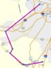
So if you try to fly your KML file in Google earth Pro, it would take you literally through the mountains. Following the straight lines, straight into one side of a hill and emerge nursing a nasty headache at the other side. No. That is no good. What GEP needs is the route itself, not just the points that represent the individual route points.

If you have the Basecamp maps of your area, then get Basecamp to create the route from your points and export that as a new KML file. Load that into Google Earth.

If you don't have the Basecamp maps, then it needs different solution that does the same job of creating a route along roads and creating a new KML file that plots the twisty windy route along roads.

One way that is nice and convenient is to use MyRouteApps. But other methods also exist - and the software that you use already may have the facility to create a route and export it to a new kml file - I don't know.

MyRouteApp wll allows you to set up a free account.
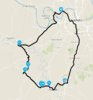
Load in your direct route KML file. MRA will immediately create a twisty-turny route along roads - like the screen shot below - although it seems to have joined the end back to the beginning. I've not bothered to find out why.

UP KML file in MRA.jpg


Don't do anything with it except save it again, choosing the KML file option. It will save it with exactly the same name but with a number in brackets added.

Then load that new kml file into Google Earth Pro.

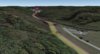
When I tried it, the route showed up as a very fine white line. (So it almost didn't show up). It will still fly the route when you click the 'Play Tour' button

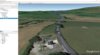
But if you want to make the route line easier to see, before clicking on the 'Play Tour' button, you right click on the track that you have selected to get the pop up menu, and then select properties, you can select the colour, width and opacity of the track that is displayed. I'm on a PC - you will have to translate that last instruction to Mac-speak if you use a Mac.


UP MRA KML File in GEP.jpg

If you need more detail, I will happily provide it.

I've attached the twisty curvy kml file below so that you can use it to try the google earth flying bit without doing the part with software like MyRouteApp or Basecamp.
 

Attachments

Last edited:

Wes

Site Supporter
Joined
Jun 18, 2018
Messages
312
Age
64
Location
Niceville, FL
Bike
07 ST1300, DRZ400S
I'm not using BaseCamp, so I would need to put in a lot more 'waypoints' if I want to do a 'flyover'.
Oh well, as we say out in the country - "Too much sugar for a nickel!" :biggrin:
Thanks anyway.
Don't give up yet! There's always a solution!;)

Whatever software you're using to create your route, you should be able to export as a track. If that exported "track" file is still a .gpx rather than a kml, then go to https://gpx2kml.com and it will convert it to kml for you. After the conversion, it will allow you to view it on a map to confirm it converted it correctly. Then use that new file with Google Earth Pro.
 

Uncle Phil

Site Supporter
Joined
Feb 26, 2007
Messages
11,350
Age
71
Location
In The Holler West Of Nashville, Tennessee
Bike
4 ST1100(s)
2024 Miles
006717
STOC #
698
Well, the routes are made in MS Streets & Trips (.est files), GPSBabeled to KML files.
I think the issue is that in MS Streets & Trips and my GPS, they don't need a bunch of waypoints to select the streets.
So I just put enough in to 'force' the GPS to go the way that I want.
 
Top Bottom