New Garmin Zumo XT

paulcb

- - - Tetelestai - - - R.I.P. - 2022/05/26
Rest In Peace
Joined
Jun 4, 2013
Messages
4,647
Location
Celina, TX
Bike
'97/'01 ST1100 ABSII
STOC #
8735
Wow, not a bad price either, compared to what I was expecting. Nice find.
 

The Cheese

Hmmmm tempting..... How would you mount it on the ST?
Likely using a Ram mounting system.

It comes with a motorcycle mount and power cord. Appears to be an AMPS pattern. Garmin even lists a handlebar mount for an additional $60.

It does look pretty good. Might get me to upgrade from a 660lm. It really doesn't seem to do anything better than my Zumo but the bigger and brighter screen would be really nice. Will wait for some real world reviews.

The website says map updates are included. I wonder for how long and how frequent? It does not say "Lifetime Maps"
 

wjbertrand

Ventura Highway
Joined
Feb 8, 2005
Messages
4,424
Location
Ventura, CA
This unit is the first one from Garmin, given its price point, that might temp me to upgrade from my ancient but trusty zumo 550. I would dearly miss the XM radio though...
 

ST Gui

240Robert
Site Supporter
Joined
Sep 12, 2011
Messages
9,262
Location
SF-Oakland CA
Bike
ST1300, 2010
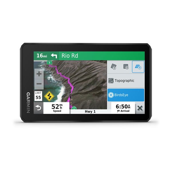
What makes this Zumo an 'adventure' navigator? I like the larger screen but on the site the 'traveled' area is practically dwarfed by big buttons boxes and windows. It this age of voice control most should disappear and reappear on command. The price is cheaper than I'd have guessed but you're not getting more for less.
 

SupraSabre

48 Years of SoCal Lane Splitting/Commuting-Retired
Site Supporter
Joined
Nov 20, 2005
Messages
9,518
Location
Cedar City, Utah
Bike
12/04 ST 1300s
2024 Miles
000420
STOC #
5901
Hum, I'm not seeing that it will play mp3's ? :think1:

I'm still using my GPS to play my mp3s...
 
OP
OP
bdalameda

bdalameda

PaleoCyclist
Joined
Jan 13, 2009
Messages
2,417
Age
67
Location
Salinas, California
Bike
Africa Twin
What makes this Zumo an 'adventure' navigator? I like the larger screen but on the site the 'traveled' area is practically dwarfed by big buttons boxes and windows. It this age of voice control most should disappear and reappear on command. The price is cheaper than I'd have guessed but you're not getting more for less.
Mainly it is more friendly for Adventure riding because it can use off-road mapping etc. Topo maps etc. and has Birdseye Satellite imaging and weather with backtracking capability like other off-road or handheld GPS devices - other than that it is just as capable for on-road as any GPS. It also will interface directly with your InReach tracking and satellite messenger.
 
Last edited:
Joined
Mar 27, 2019
Messages
1,102
Location
Georgia
Bike
98 & 99 ST1100
STOC #
673
The new product provides connectivity with their InReach product for a plus and leaves behind Garmin TPMS compatibility as a negative. With Garmin it is not enough to question whether the 590/595 glitches are gone without asking what new glitches are introduced - unless this is the first glitchless Garmin product. You also get to invest in new mounting and powering hardware, which if you have multiple bikes can get painful.

As someone who has been with Garmin since my 1998 StreetPilot, I'm no basher, but I"m working on an Android replacement using the bulletproof Kyocera Duraforce Pro with Sapphire Shield or a Samsung Galaxy Active Tab 2 for a larger screen display. Either of these can run GPS apps (Osmand, Locus, Sygic, CoPilot, TomTom, etc.) without a phone account if wanted, but with a phone account you bring the possibilities of Waze or Google. Waze provides better odds now of helping you avoid a speeding ticket than a ValentineOne. Google with downloaded maps can also run sans phone account.

Garmin had no market choice but to drop $2-300 from their normally punitive starting prices because the alternatives are getting much better and much less expensive. IMO the three things holding the Android apps back the most have been (1) the right hardware to run them on given the hostile bike environment (heat, direct sunlight, waterproofness); (2) the learning curve and complexity of getting the apps to work as you want them; and (3) controls that can be manipulated with gross motor skills - i.e. not trying to tag a miniscule icon with a fat gloved finger while operating the bike. Progress is occurring on all of these fronts.
 

ST Gui

240Robert
Site Supporter
Joined
Sep 12, 2011
Messages
9,262
Location
SF-Oakland CA
Bike
ST1300, 2010
other than that it is just as capable for on-road as any GPS.
I'd expect that as a given or it'd be no sale. Not an adventure rider I'm not familiar with 'off-road mapping'. How is that different from on-road mapping. Satellite imaging or view (actual?) is a nice touch. I use it from time to time on my phone though I don't know that all images are from satellite. My only grip is not giving the map area more real estate.
 
Joined
Sep 12, 2019
Messages
73
Age
67
Location
Scottsdale, Az
Mainly it is more friendly for Adventure riding because it can use off-road mapping etc. Topo maps etc. and has Birdseye Satellite imaging and weather with backtracking capability like other off-road or handheld GPS devices - other than that it is just as capable for on-road as any GPS. It also will interface directly with your InReach tracking and satellite messenger.
Do you use an InReach tracker? I live in AZ and often ride up in the mountains where there is little or no cell. When I first bought my ST - the battery died up in the middle of nowhere and it took me four hours to get out of there. It was my fault as I walked away from the bike without turning it off which made me feel even more stupid but hey... it happens. At that time I thought it owuld be nice to have a sat phone but the cost is a but more than I wanted to spend.
 

ST Gui

240Robert
Site Supporter
Joined
Sep 12, 2011
Messages
9,262
Location
SF-Oakland CA
Bike
ST1300, 2010
beemerphile said:
I"m working on an Android replacement using the bulletproof Kyocera Duraforce Pro with Sapphire Shield or a Samsung Galaxy Active Tab 2 for a larger screen display. Either of these can run GPS apps (Osmand, Locus, Sygic, CoPilot, TomTom, etc.)...

Garmin had no market choice but to drop $2-300 from their normally punitive starting prices because the alternatives are getting much better and much less expensive.
I believe the above is why Garmin pulled its excellent Navigon app from the market. It was a full fledged fully bake app that could compete with any standalone GPS unit with the actual hardware being the only difference.

The DuoForce option as mentioned here awhile back is intriguing. Finding a clean used phone at a reasonable price is not my forte. I do have Scenic TomTom (no purchased extra) and CoPilot on my phone but have yet to play around with any. Still missing Navigon.
 
OP
OP
bdalameda

bdalameda

PaleoCyclist
Joined
Jan 13, 2009
Messages
2,417
Age
67
Location
Salinas, California
Bike
Africa Twin
Do you use an InReach tracker? I live in AZ and often ride up in the mountains where there is little or no cell. When I first bought my ST - the battery died up in the middle of nowhere and it took me four hours to get out of there. It was my fault as I walked away from the bike without turning it off which made me feel even more stupid but hey... it happens. At that time I thought it owuld be nice to have a sat phone but the cost is a but more than I wanted to spend.
Yes I have an InReach Explorer and use it a lot when I am off on my own riding where there is no cell service - it is nice to be able to communicate for just checking in or to be able to call in the Cavalry if there is an accident etc.
 
OP
OP
bdalameda

bdalameda

PaleoCyclist
Joined
Jan 13, 2009
Messages
2,417
Age
67
Location
Salinas, California
Bike
Africa Twin
I'd expect that as a given or it'd be no sale. Not an adventure rider I'm not familiar with 'off-road mapping'. How is that different from on-road mapping. Satellite imaging or view (actual?) is a nice touch. I use it from time to time on my phone though I don't know that all images are from satellite. My only grip is not giving the map area more real estate.
The Topo maps show topographical information and a lot of trails and associated dirt roads and points of interest that are not on regular road maps or street oriented GPS maps. I use Topo maps a lot when in my Jeep off-road and also my Africa Twin when riding dirt roads and trails etc. One of my hobbies that I combine with my riding is finding old historical sites that are off out in the wild in remote locations. I've spent a lot of time in Wyoming riding and driving many of the old pioneer trails and cutoffs and locating interesting historical points along the way that are mostly forgotten by time. On my Africa Twin I have a Garmin GPSMap 640 which is larger than the on-road GPS devices. It was made for both on-road and Marine applications but has the capability of using Topo maps as well as Satellite weather and Birdseye imaging. It also is equipped with XM radio which is nice as well as traffic monitoring. These are no longer made by Garmin but are still used by a lot of boat owners and well supported.
 
Last edited:
OP
OP
bdalameda

bdalameda

PaleoCyclist
Joined
Jan 13, 2009
Messages
2,417
Age
67
Location
Salinas, California
Bike
Africa Twin
Here is an interesting tidbit of history I found last summer. This is the actual cabin that Amelia Earhart staying in while visiting the Double-Dee ranch in the Absoroaka mountains near the Ghost town of Kirwin Wyoming. She loved this area and stayed in this cabin before leaving on her round-the world flight and had made an agreement with Carl Dunrud, the owner of the Double-Dee, to build her a cabin of her own up the canyon a couple of miles. Carl started to build her cabin but quit the construction when she disappeared. The logs of the Cabin that Carl was building for her are still visible.
 

Attachments

Joined
Sep 24, 2018
Messages
467
Since Garmin likes to route vehicles down goat trails it should be spectacular for adventure riding.
 

SupraSabre

48 Years of SoCal Lane Splitting/Commuting-Retired
Site Supporter
Joined
Nov 20, 2005
Messages
9,518
Location
Cedar City, Utah
Bike
12/04 ST 1300s
2024 Miles
000420
STOC #
5901
From Garmin:
MUSIC
Stream music from your smartphone through the zūmo XT navigator, or play MP3 files stored on the navigator — all to your connected helmet or headset.

HAHA! I guess I missed it...

Motorcycle Features
GLOVE-FRIENDLY TOUCHSCREEN
CONTROL MUSIC AND MEDIA FROM SMARTPHONE
OR MP3 PLAYER

Good, glad to see that there. :thumb:

One of these days I need to thin out my 4,000 songs to the ones I like...:think1:
 
Top Bottom