Replacing dedicated GPS device with Smart Phone

Shawn K

Professional Cat Confuser
Joined
Oct 11, 2008
Messages
982
Location
Boiling Springs, SC
Bike
GL1800
STOC #
9012
I have had it shut down on overheat a few times though.
That's been my biggest complaint about the cell phones I've used for navigation. At some point, every one of them went into thermal shutdown. It made no difference if they were running on batteries or wired to the bike.
 

T_C

Joined
Mar 8, 2012
Messages
4,336
Location
St. Louis, MO
Bike
2005 St1300
STOC #
8568
That's been my biggest complaint about the cell phones I've used for navigation. At some point, every one of them went into thermal shutdown. It made no difference if they were running on batteries or wired to the bike.
How hot do you have to get it. I've had mine pause the charge because temperature was too high or too low. But never had a full shutdown... unless battery drops below the minimum charge.
 

Shawn K

Professional Cat Confuser
Joined
Oct 11, 2008
Messages
982
Location
Boiling Springs, SC
Bike
GL1800
STOC #
9012
How hot do you have to get it. I've had mine pause the charge because temperature was too high or too low. But never had a full shutdown... unless battery drops below the minimum charge.
I can't give you a number. All I can say is that it happens on long rides on hot days. Screens full brightness, map app navigating, that kind of thing.
 
Joined
Apr 10, 2018
Messages
1,291
Location
Martha Lake
Bike
F900 XR
2024 Miles
000800
How do you watch the screen and the twisty road at the same time?
Actually, it is easy. Sort of. ;)

My old Navigon GPS was perfect for that. The perspective it gave told you at a glance what the upcoming corner was like...and the next couple as well, so you had no surprises.

I made it a practice when I bought a GPS to use it constantly for a few days on roads where I knew where I was going. The idea was to get familiar with where on the screen the information I needed was located at, and to get familiar with the controls. It was also helpful to see how the routing worked, or didn't work.

Many of the GPS's zoom in as you slow down, and back out when your speed increases. You'll also see the info on which road you're currently on, and what the upcoming road will be, and how much further to go prior to that turn.

@Shawk K - thanks for the clarification. I was hoping that with a bad ESN, that it would be cheaper. That doesn't seem to be the case though.

Chris
 
Joined
Apr 10, 2018
Messages
1,291
Location
Martha Lake
Bike
F900 XR
2024 Miles
000800
That's been my biggest complaint about the cell phones I've used for navigation. At some point, every one of them went into thermal shutdown. It made no difference if they were running on batteries or wired to the bike.
I wonder if a white phone would help alleviate the heat?

On the Friday for the Ride the Ribbon rally, we were in the high 80s from about Yakima on south. By the time we crossed the Columbia River, it was in the high 90s. And for the last 3 hours of riding, it was at or over 100. That would mean that probably 5 of the hours of riding would have a smartphone shut down for overheating.

Chris
 

ST Gui

240Robert
Site Supporter
Joined
Sep 12, 2011
Messages
9,264
Location
SF-Oakland CA
Bike
ST1300, 2010
I found the reality to be less of an issue than the potential issue before I tried it. They do cover a lot of the screen. Perhaps so you have room to press the controls with a glove on? What is left for the route display though is enough that I haven't missed it.
Good to know! Fair point about gloved fingers.

And as for Portrait vs Landscape...It seems to leave you with just about the same amount of a display on each viewing mode.
That may be the case in sq. in. or mm. But I find the elongation showing more of what's in front especailly useful. Looking at the static pic of portrait mode gives me the sense of more area especially with the blocks spread out a little more.
 

ST Gui

240Robert
Site Supporter
Joined
Sep 12, 2011
Messages
9,264
Location
SF-Oakland CA
Bike
ST1300, 2010
I enjoy having nav in my cars, but on my bike I’m a bit old school. I don’t see the need to have an electronic device taking my attention away from the road.
How would a GPS take away your attention on a bike but not in a car? I see no real difference unless having 3500lbs of metal wrapped around you means crashing into somebody give you a better chance of walking away. Otherwise it's a matter of managing sensory input. You don't close your eyes before walking down the sidewalk or crossing the street. Or read a book or bury your attention in a phone. (Yeah I know people who do but that's a different rant.)
 

ST Gui

240Robert
Site Supporter
Joined
Sep 12, 2011
Messages
9,264
Location
SF-Oakland CA
Bike
ST1300, 2010
How do you watch the screen and the twisty road at the same time?
Maybe by looking at one before the other. It only takes a quick glance to see what the road ahead looks like for quite a distance. So you pick and choose when to look. It's not like you have to consult the GPS before every.single.turn to know what the next several will be like. I don't think most of us are doing —

"Ok, two tight rights and a sweeping left - oh look it has my old school on the map. I remember before Peggy Sue got married we used to cut class and sneak across the street to the Dairy Que— ".
 

Shawn K

Professional Cat Confuser
Joined
Oct 11, 2008
Messages
982
Location
Boiling Springs, SC
Bike
GL1800
STOC #
9012
Maybe by looking at one before the other. It only takes a quick glance to see what the road ahead looks like for quite a distance. So you pick and choose when to look. It's not like you have to consult the GPS before every.single.turn to know what the next several will be like. I don't think most of us are doing —

"Ok, two tight rights and a sweeping left - oh look it has my old school on the map. I remember before Peggy Sue got married we used to cut class and sneak across the street to the Dairy Que— ".
You're snarky, and I dig that about you. :biggrin::thumb:
 
Joined
Sep 24, 2018
Messages
467
Who looks at sceeen. I listen to directions in bluetooth.
Never had a phone shut down in heat. But ive only ridden cross country 8 or 9 times. 116 the hottest i can remember.
Had one get crazy in the rain once, coming home from moonshine lr.
 
OP
OP
rjs987

rjs987

Robert
Site Supporter
Joined
Sep 25, 2009
Messages
3,058
Age
68
Location
West Des Moines, IA
Bike
2022 Kymco AK 550
2024 Miles
001392
STOC #
8058
Just returned from WISTOC using my phone as GPS again. I am currently using a Google Pixel 4 with the max memory available. That is so I can download a lot of offline maps for large areas where I might be traveling. This phone is also IP68 rated. Same as current Garmin GPS units. IP ratings are for Intrusion Protection (or Prevention). The first number is for solids or dust, the second number is for liquids like water. The "8" rating for water means I can drop my phone in the pool 1.5 meters deep for a half hour. I rode for 5.5 hours (riding time) to the event in a very steady soaking rain all the way and the phone worked great. I now usually start out with a full charge on the phone and then plug in after lunch. That's 3.5 hours of routing with the display on and voice prompts for turn by turn to my BT headset before the battery is down to 40% battery life. Then I plug in for the rest of the trip and arrive with a full charge on the phone.

There is only one issue I've found using a phone as GPS in heavy rain... rain drops coming off the shield that fall on the screen are sometimes, but not often, detected as a random touch of the finger on the screen. I keep a touch screen pen clipped to my modified x-grip (from AliExpress) but have also found my gloves do work on the screen to cancel any such random "touches" when they are wet. My summer gloves also have a special surface made to work on touch screens on the index finger and thumb.

Google bought Waze some time ago and has been slowly moving many of the features in Waze into Google Maps Navigate. But so far this only enhances what is displayed. The one big feature I'd like to see implemented is an auto-resume when a "stop point" is reached. Currently I do have to tap "Continue" to resume navigating. Not a biggie yet though since I usually set any stop points at a planned gas or lunch stop so I'm off the bike and will tap Continue when I start up again. I've also put my phone in my pocket and just listened to the turn by turn voice prompts without having the map in view. I prefer having the map in view however. Like others have said when coming up on a really curvy section of road (curves for the next 3 miles, etc.) I usually look once just before entering a series of curves and then concentrate on watching the road. There are still the voice prompts if there is a turn in the middle. I also VERY MUCH like only having 2 prompts for all upcoming turns rather than the half dozen that Garmin gives. Depending how fast I'm moving Google Maps tells me to turn in a half mile (when faster) or in a quarter mile (when slower) and then when I'm close it tells me to turn at the next right or left. Or if there is another road/alley very close to the turn (like within 25 yards) it will tell me to take the second right or left. It has even told me to turn just after XXX business that is on the corner.
 

ST Gui

240Robert
Site Supporter
Joined
Sep 12, 2011
Messages
9,264
Location
SF-Oakland CA
Bike
ST1300, 2010
Who looks at sceeen. I listen to directions in bluetooth.
In the city I listen to the turn by turn with never a need to look at the GPS. But on rural stuff playing 'Almost Keeping Up' with my much faster buddies I do like to see if there's a tight turn in my future or if I need to slow down before running out of what little talent I have. We all have 20Ss so they may be out of sight but at least we'll be in radio contact as I go screaming like a little girl while plummeting off the side of the road.


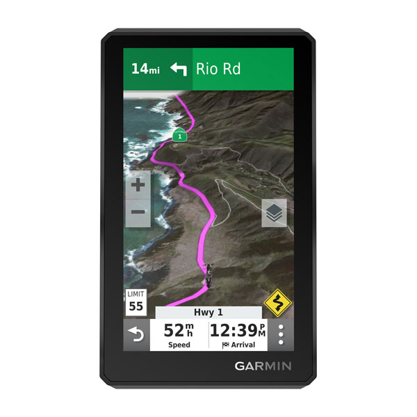
A quick glance and seeing something like this tells me I don't have to do any box breathing for awhile. So I'm following VFR rules not IFR. That stretch of Hwy 1 is about 100mi south of me. Not a particularly challenging road (aside from rock or mudslides). Just the way I like it. :D
 

rwthomas1

Site Supporter
Joined
Jun 6, 2020
Messages
1,151
Location
Rhode Island, USA
Bike
'01 ST1100 non-ABS
It appears that Waze loads the maps needed for a route in advance. As long as you stay on the route that Waze planned, loss of cell coverage doesn't seem to bother it. Now, leave the planned route and you better have cell coverage so Waze can fill in the new route. Had this happen a few times. Annoying enough that if going off the beaten track regularly, I'd like an offline dedicated program. That said, Waze is excellent for routing around traffic and police alerts.

Never had a cellphone overheat and shutdown. I prefer the Samsung Galaxy products. I think if I was touring and not just commuting, I'd consider a dedicated GPS unit.

RT
 
OP
OP
rjs987

rjs987

Robert
Site Supporter
Joined
Sep 25, 2009
Messages
3,058
Age
68
Location
West Des Moines, IA
Bike
2022 Kymco AK 550
2024 Miles
001392
STOC #
8058
Again... That's why I download maps of a large area where I'll be riding. I've lost cell coverage many times while riding but not navigation since I downloaded the maps so Google Maps Navigate uses the downloaded version and keeps on going regardless if I stay on track or go exploring. I can even make new routes using the downloaded maps while sitting where there is no cell service. BTDT many times as well.
 

Shawn K

Professional Cat Confuser
Joined
Oct 11, 2008
Messages
982
Location
Boiling Springs, SC
Bike
GL1800
STOC #
9012
Having been on both sides of this equation (using cell phones with or without cellular service, and having used standalone GPS units), I've found that ever since I purchased my Garmin 396 LMT-S and downloaded the Garmin Smartlink app, I don't even want to use my phone for navigation anymore.

It's quite nice to have a GPS that just works, doesn't care if I'm wearing gloves or not, can be easily read at high noon or darkest night, is easily removed and placed in the trunk, and doesn't give a whit if it's hot or cold, sunny or wet. Every smartphone solution I've tried came with a caveat. My Garmin 396 hasn't.

Every use case is different, I suppose, but for my two cents a proper weatherized motorcycle GPS is just easy. And when you ride like I do, easy is what you want.

(Tip of the hat to Ryan F9 for that last line.)
 

drrod

Site Supporter
Joined
Aug 4, 2006
Messages
1,706
Location
Calgary, Alberta
Bike
'04 ST1300
STOC #
8313
My Garmin 396 hasn't.
I would suggest that Garmin comes with the caveat "you are stuck with Garmin maps, navigation algorithm and user interface".
May not be an issue for some, but for others it may be. Probably depends on individual needs/wants. Nice to have choices.
 

Shawn K

Professional Cat Confuser
Joined
Oct 11, 2008
Messages
982
Location
Boiling Springs, SC
Bike
GL1800
STOC #
9012
I would suggest that Garmin comes with the caveat "you are stuck with Garmin maps, navigation algorithm and user interface".
May not be an issue for some, but for others it may be. Probably depends on individual needs/wants. Nice to have choices.
Unless you're adept enough to write your own code, the same can be said of ANY computer software.

You pays your dollars and you makes your choices.

Others may have different experiences, but I'm starting to find in my travels that trying to make one item that can do a thousand different things can sometimes result in not really being all that good at anything. Having a piece of kit that's really good at a single specialized thing isn't always bad.

I'm not trying to sway anyone. All I'm saying is that in the end and after many tens of thousands of miles of experimentation, my personal experience was that using smartphones as GPS units turned out to have more drawbacks than benefits. But if someone else wants to use their phone, then more power to 'em.
 

drrod

Site Supporter
Joined
Aug 4, 2006
Messages
1,706
Location
Calgary, Alberta
Bike
'04 ST1300
STOC #
8313
Unless you're adept enough to write your own code, the same can be said of ANY computer software.
That is true. But with the various smartphone apps, you don't have to pay your money (or at least minimal) and thus it makes it easy to try out various ones. Conversely, you pay several hundred dollars just to try out Garmin/TomTom, etc. stand alone unit as well as $100+ dollars for maps that do not come with your LM updates and they are locked to an individual device. eg. Western Europe maps for Garmin cost $100+, Australia/Oceania cost $200+

Smartphone GPS apps are still in their relative infancy. I would expect, given the rate of progress in the field, that in the not too distant future, they are going to have the lion's share of the market. That being said, there will always be a place for stand alones and that is a good thing. Not unlike our beloved ST. Does a great job at what it was designed to do but there are alternatives for people that want them.
 
Top Bottom